You are here: Home > Network List > II - Global Seismograph Network (GSN - IRIS/IDA) Stations List
> Station DGAR Diego Garcia, Chagos Islands, Indian Ocean > Earthquake Result Viewer
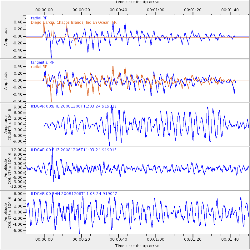
DGAR Diego Garcia, Chagos Islands, Indian Ocean - Earthquake Result Viewer
*The percent match for this event was below the threshold and hence no stack was calculated.
| Earthquake location: |
Banda Sea |
| Earthquake latitude/longitude: |
-7.4/124.7 |
| Earthquake time(UTC): |
2008/12/06 (341) 10:55:27 GMT |
| Earthquake Depth: |
405 km |
| Earthquake Magnitude: |
6.1 MB, 6.4 MW, 6.4 MW |
| Earthquake Catalog/Contributor: |
WHDF/NEIC |
|
| Network: |
II Global Seismograph Network (GSN - IRIS/IDA) |
| Station: |
DGAR Diego Garcia, Chagos Islands, Indian Ocean |
| Lat/Lon: |
7.41 S/72.45 E |
| Elevation: |
1.0 m |
|
| Distance: |
51.8 deg |
| Az: |
266.39 deg |
| Baz: |
93.581 deg |
| Ray Param: |
$rayparam |
*The percent match for this event was below the threshold and hence was not used in the summary stack. |
|
| Radial Match: |
42.373093 % |
| Radial Bump: |
367 |
| Transverse Match: |
55.615726 % |
| Transverse Bump: |
400 |
| SOD ConfigId: |
2658 |
| Insert Time: |
2010-03-01 20:27:42.886 +0000 |
| GWidth: |
2.5 |
| Max Bumps: |
400 |
| Tol: |
0.001 |
|
Signal To Noise
| Channel | StoN | STA | LTA |
| II:DGAR:00:BHZ:20081206T11:03:24.91901Z | 3.9181402 | 3.97486E-6 | 1.0144763E-6 |
| II:DGAR:00:BHN:20081206T11:03:24.91901Z | 0.95115745 | 2.6885286E-6 | 2.8265863E-6 |
| II:DGAR:00:BHE:20081206T11:03:24.91901Z | 1.4695636 | 3.6391712E-6 | 2.476362E-6 |
| Arrivals |
| Ps | |
| PpPs | |
| PsPs/PpSs | |


