You are here: Home > Network List > ZJ12 - Transantarctic Mountains Northern Network Stations List
> Station SHRD Lister Nunataks, Antarctica > Earthquake Result Viewer
SHRD Lister Nunataks, Antarctica - Earthquake Result Viewer
| Earthquake location: |
Mendoza Province, Argentina |
| Earthquake latitude/longitude: |
-32.7/-67.1 |
| Earthquake time(UTC): |
2015/02/02 (033) 10:49:48 GMT |
| Earthquake Depth: |
172 km |
| Earthquake Magnitude: |
6.3 MO |
| Earthquake Catalog/Contributor: |
NEIC PDE/NEIC ALERT |
|
| Network: |
ZJ Transantarctic Mountains Northern Network |
| Station: |
SHRD Lister Nunataks, Antarctica |
| Lat/Lon: |
73.40 S/160.50 E |
| Elevation: |
2457 m |
|
| Distance: |
69.4 deg |
| Az: |
193.099 deg |
| Baz: |
138.35 deg |
| Ray Param: |
0.055185817 |
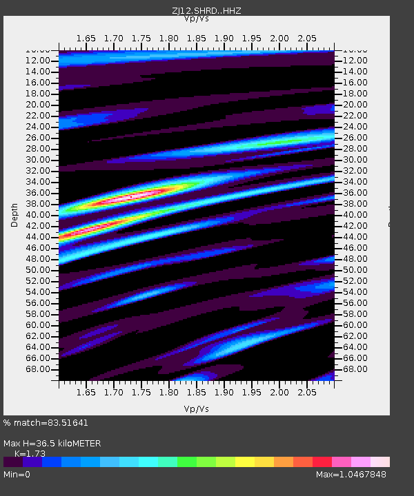
| Estimated Moho Depth: |
36.5 km |
| Estimated Crust Vp/Vs: |
1.73 |
| Assumed Crust Vp: |
6.264 km/s |
| Estimated Crust Vs: |
3.621 km/s |
| Estimated Crust Poisson's Ratio: |
0.25 |
|
| Radial Match: |
83.51641 % |
| Radial Bump: |
348 |
| Transverse Match: |
71.99314 % |
| Transverse Bump: |
400 |
| SOD ConfigId: |
6981111 |
| Insert Time: |
2019-04-16 12:00:48.350 +0000 |
| GWidth: |
2.5 |
| Max Bumps: |
400 |
| Tol: |
0.001 |
|

Signal To Noise
| Channel | StoN | STA | LTA |
| ZJ:SHRD: :HHZ:20150202T11:00:07.059985Z | 18.743284 | 2.5937948E-6 | 1.3838527E-7 |
| ZJ:SHRD: :HHN:20150202T11:00:07.059985Z | 6.273376 | 7.487288E-7 | 1.1935022E-7 |
| ZJ:SHRD: :HHE:20150202T11:00:07.059985Z | 3.942351 | 5.46295E-7 | 1.3857087E-7 |
| Arrivals |
| Ps | 4.4 SECOND |
| PpPs | 15 SECOND |
| PsPs/PpSs | 20 SECOND |


