You are here: Home > Network List > II - Global Seismograph Network (GSN - IRIS/IDA) Stations List
> Station DGAR Diego Garcia, Chagos Islands, Indian Ocean > Earthquake Result Viewer
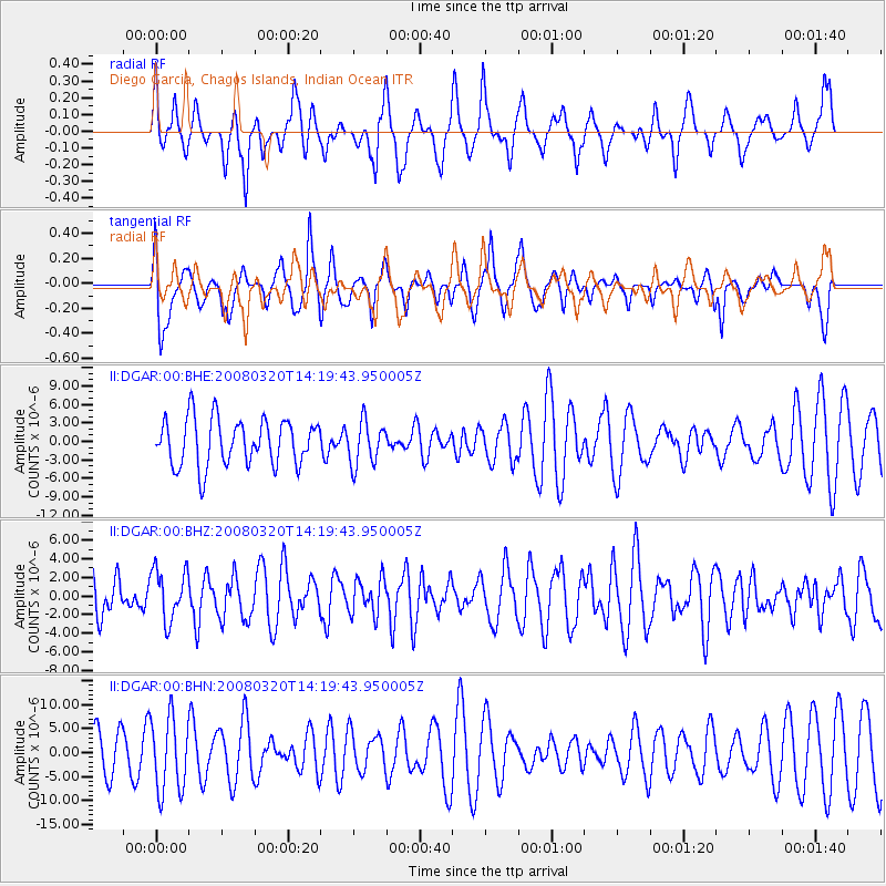
DGAR Diego Garcia, Chagos Islands, Indian Ocean - Earthquake Result Viewer
*The percent match for this event was below the threshold and hence no stack was calculated.
| Earthquake location: |
Mindanao, Philippines |
| Earthquake latitude/longitude: |
6.2/126.9 |
| Earthquake time(UTC): |
2008/03/20 (080) 14:10:44 GMT |
| Earthquake Depth: |
82 km |
| Earthquake Magnitude: |
6.0 MB, 6.1 MW, 6.1 MW |
| Earthquake Catalog/Contributor: |
WHDF/NEIC |
|
| Network: |
II Global Seismograph Network (GSN - IRIS/IDA) |
| Station: |
DGAR Diego Garcia, Chagos Islands, Indian Ocean |
| Lat/Lon: |
7.41 S/72.45 E |
| Elevation: |
1.0 m |
|
| Distance: |
56.0 deg |
| Az: |
256.82 deg |
| Baz: |
77.456 deg |
| Ray Param: |
$rayparam |
*The percent match for this event was below the threshold and hence was not used in the summary stack. |
|
| Radial Match: |
49.744003 % |
| Radial Bump: |
400 |
| Transverse Match: |
63.51122 % |
| Transverse Bump: |
400 |
| SOD ConfigId: |
2504 |
| Insert Time: |
2010-03-01 20:28:03.712 +0000 |
| GWidth: |
2.5 |
| Max Bumps: |
400 |
| Tol: |
0.001 |
|
Signal To Noise
| Channel | StoN | STA | LTA |
| II:DGAR:00:BHZ:20080320T14:19:43.950005Z | 0.8052186 | 2.740602E-6 | 3.4035502E-6 |
| II:DGAR:00:BHN:20080320T14:19:43.950005Z | 2.1614618 | 7.71563E-6 | 3.5696348E-6 |
| II:DGAR:00:BHE:20080320T14:19:43.950005Z | 0.9285896 | 3.5170178E-6 | 3.7874834E-6 |
| Arrivals |
| Ps | |
| PpPs | |
| PsPs/PpSs | |


