You are here: Home > Network List > TA - USArray Transportable Network (new EarthScope stations) Stations List
> Station K49A Clarkson, MI, USA > Earthquake Result Viewer
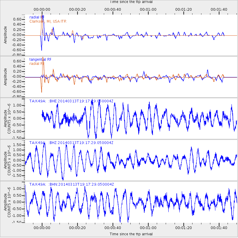
K49A Clarkson, MI, USA - Earthquake Result Viewer

| Earthquake location: |
Off Coast Of Northern California |
| Earthquake latitude/longitude: |
41.9/-126.9 |
| Earthquake time(UTC): |
2014/03/13 (072) 19:11:34 GMT |
| Earthquake Depth: |
10 km |
| Earthquake Magnitude: |
5.5 MWW, 4.0 ML, 5.5 MWC, 5.6 MI |
| Earthquake Catalog/Contributor: |
NEIC PDE/NEIC COMCAT |
|
| Network: |
TA USArray Transportable Network (new EarthScope stations) |
| Station: |
K49A Clarkson, MI, USA |
| Lat/Lon: |
42.78 N/83.46 W |
| Elevation: |
336 m |
|
| Distance: |
31.9 deg |
| Az: |
73.544 deg |
| Baz: |
283.481 deg |
| Ray Param: |
0.07889738 |
| Estimated Moho Depth: |
15.5 km |
| Estimated Crust Vp/Vs: |
1.91 |
| Assumed Crust Vp: |
6.483 km/s |
| Estimated Crust Vs: |
3.394 km/s |
| Estimated Crust Poisson's Ratio: |
0.31 |
|
| Radial Match: |
86.26413 % |
| Radial Bump: |
400 |
| Transverse Match: |
37.010136 % |
| Transverse Bump: |
400 |
| SOD ConfigId: |
626651 |
| Insert Time: |
2014-04-22 15:53:53.732 +0000 |
| GWidth: |
2.5 |
| Max Bumps: |
400 |
| Tol: |
0.001 |
|
Signal To Noise
| Channel | StoN | STA | LTA |
| TA:K49A: :BHZ:20140313T19:17:29.050004Z | 2.954184 | 1.0523399E-6 | 3.5622017E-7 |
| TA:K49A: :BHN:20140313T19:17:29.050004Z | 0.8244809 | 5.6284733E-7 | 6.8266877E-7 |
| TA:K49A: :BHE:20140313T19:17:29.050004Z | 2.5437355 | 8.8628656E-7 | 3.484193E-7 |
| Arrivals |
| Ps | 2.3 SECOND |
| PpPs | 6.5 SECOND |
| PsPs/PpSs | 8.8 SECOND |


