You are here: Home > Network List > TA - USArray Transportable Network (new EarthScope stations) Stations List
> Station K62A Royalston, MA, USA > Earthquake Result Viewer
K62A Royalston, MA, USA - Earthquake Result Viewer

| Earthquake location: |
Off Coast Of Northern California |
| Earthquake latitude/longitude: |
41.9/-126.9 |
| Earthquake time(UTC): |
2014/03/13 (072) 19:11:34 GMT |
| Earthquake Depth: |
10 km |
| Earthquake Magnitude: |
5.5 MWW, 4.0 ML, 5.5 MWC, 5.6 MI |
| Earthquake Catalog/Contributor: |
NEIC PDE/NEIC COMCAT |
|
| Network: |
TA USArray Transportable Network (new EarthScope stations) |
| Station: |
K62A Royalston, MA, USA |
| Lat/Lon: |
42.67 N/72.23 W |
| Elevation: |
289 m |
|
| Distance: |
39.8 deg |
| Az: |
69.899 deg |
| Baz: |
288.118 deg |
| Ray Param: |
0.07474478 |
| Estimated Moho Depth: |
17.0 km |
| Estimated Crust Vp/Vs: |
1.89 |
| Assumed Crust Vp: |
6.419 km/s |
| Estimated Crust Vs: |
3.401 km/s |
| Estimated Crust Poisson's Ratio: |
0.30 |
|
| Radial Match: |
85.11939 % |
| Radial Bump: |
400 |
| Transverse Match: |
40.970352 % |
| Transverse Bump: |
375 |
| SOD ConfigId: |
626651 |
| Insert Time: |
2014-04-22 15:54:20.247 +0000 |
| GWidth: |
2.5 |
| Max Bumps: |
400 |
| Tol: |
0.001 |
|
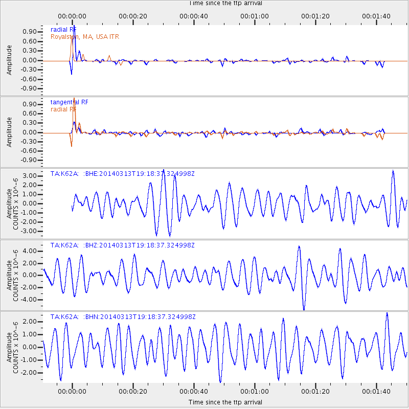
Signal To Noise
| Channel | StoN | STA | LTA |
| TA:K62A: :BHZ:20140313T19:18:37.324998Z | 2.2492175 | 2.303028E-6 | 1.0239241E-6 |
| TA:K62A: :BHN:20140313T19:18:37.324998Z | 1.033786 | 9.891525E-7 | 9.568251E-7 |
| TA:K62A: :BHE:20140313T19:18:37.324998Z | 3.270661 | 2.3855157E-6 | 7.293681E-7 |
| Arrivals |
| Ps | 2.5 SECOND |
| PpPs | 7.2 SECOND |
| PsPs/PpSs | 9.7 SECOND |


