You are here: Home > Network List > TA - USArray Transportable Network (new EarthScope stations) Stations List
> Station N49A Columbus Grove, OH, USA > Earthquake Result Viewer
N49A Columbus Grove, OH, USA - Earthquake Result Viewer
| Earthquake location: |
Off Coast Of Northern California |
| Earthquake latitude/longitude: |
41.9/-126.9 |
| Earthquake time(UTC): |
2014/03/13 (072) 19:11:34 GMT |
| Earthquake Depth: |
10 km |
| Earthquake Magnitude: |
5.5 MWW, 4.0 ML, 5.5 MWC, 5.6 MI |
| Earthquake Catalog/Contributor: |
NEIC PDE/NEIC COMCAT |
|
| Network: |
TA USArray Transportable Network (new EarthScope stations) |
| Station: |
N49A Columbus Grove, OH, USA |
| Lat/Lon: |
40.92 N/84.18 W |
| Elevation: |
225 m |
|
| Distance: |
31.8 deg |
| Az: |
77.216 deg |
| Baz: |
286.118 deg |
| Ray Param: |
0.07891862 |
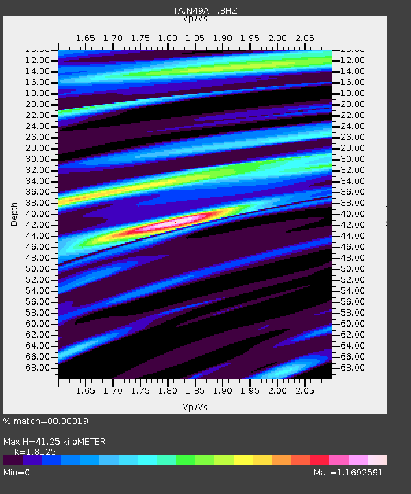
| Estimated Moho Depth: |
41.25 km |
| Estimated Crust Vp/Vs: |
1.81 |
| Assumed Crust Vp: |
6.498 km/s |
| Estimated Crust Vs: |
3.585 km/s |
| Estimated Crust Poisson's Ratio: |
0.28 |
|
| Radial Match: |
80.08319 % |
| Radial Bump: |
400 |
| Transverse Match: |
59.279324 % |
| Transverse Bump: |
400 |
| SOD ConfigId: |
626651 |
| Insert Time: |
2014-04-22 15:55:22.986 +0000 |
| GWidth: |
2.5 |
| Max Bumps: |
400 |
| Tol: |
0.001 |
|

Signal To Noise
| Channel | StoN | STA | LTA |
| TA:N49A: :BHZ:20140313T19:17:28.624009Z | 1.6435632 | 6.292009E-7 | 3.8282732E-7 |
| TA:N49A: :BHN:20140313T19:17:28.624009Z | 0.75154954 | 2.0226233E-7 | 2.6912707E-7 |
| TA:N49A: :BHE:20140313T19:17:28.624009Z | 2.4678385 | 7.7950597E-7 | 3.158659E-7 |
| Arrivals |
| Ps | 5.6 SECOND |
| PpPs | 16 SECOND |
| PsPs/PpSs | 22 SECOND |


