You are here: Home > Network List > TA - USArray Transportable Network (new EarthScope stations) Stations List
> Station O52A Adamsville, OH, USA > Earthquake Result Viewer
O52A Adamsville, OH, USA - Earthquake Result Viewer
| Earthquake location: |
Off Coast Of Northern California |
| Earthquake latitude/longitude: |
41.9/-126.9 |
| Earthquake time(UTC): |
2014/03/13 (072) 19:11:34 GMT |
| Earthquake Depth: |
10 km |
| Earthquake Magnitude: |
5.5 MWW, 4.0 ML, 5.5 MWC, 5.6 MI |
| Earthquake Catalog/Contributor: |
NEIC PDE/NEIC COMCAT |
|
| Network: |
TA USArray Transportable Network (new EarthScope stations) |
| Station: |
O52A Adamsville, OH, USA |
| Lat/Lon: |
40.12 N/81.84 W |
| Elevation: |
331 m |
|
| Distance: |
33.8 deg |
| Az: |
77.668 deg |
| Baz: |
288.017 deg |
| Ray Param: |
0.078060806 |
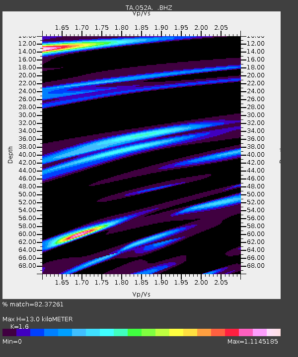
| Estimated Moho Depth: |
13.0 km |
| Estimated Crust Vp/Vs: |
1.60 |
| Assumed Crust Vp: |
6.483 km/s |
| Estimated Crust Vs: |
4.052 km/s |
| Estimated Crust Poisson's Ratio: |
0.18 |
|
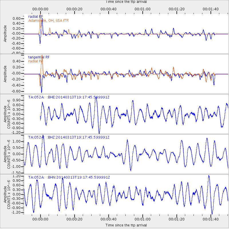
| Radial Match: |
82.37261 % |
| Radial Bump: |
400 |
| Transverse Match: |
58.5854 % |
| Transverse Bump: |
400 |
| SOD ConfigId: |
626651 |
| Insert Time: |
2014-04-22 15:55:53.942 +0000 |
| GWidth: |
2.5 |
| Max Bumps: |
400 |
| Tol: |
0.001 |
|
Signal To Noise
| Channel | StoN | STA | LTA |
| TA:O52A: :BHZ:20140313T19:17:45.599991Z | 2.0255787 | 8.2451027E-7 | 4.0704924E-7 |
| TA:O52A: :BHN:20140313T19:17:45.599991Z | 0.8451487 | 4.5075979E-7 | 5.333497E-7 |
| TA:O52A: :BHE:20140313T19:17:45.599991Z | 2.3626626 | 7.686543E-7 | 3.2533393E-7 |
| Arrivals |
| Ps | 1.3 SECOND |
| PpPs | 4.8 SECOND |
| PsPs/PpSs | 6.1 SECOND |


