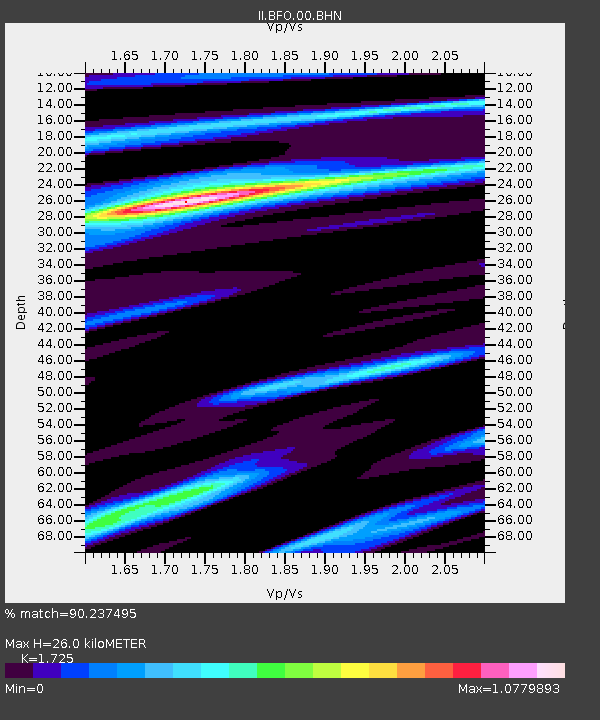
BFO Black Forest Observatory, Schiltach, Germany - Earthquake Result Viewer
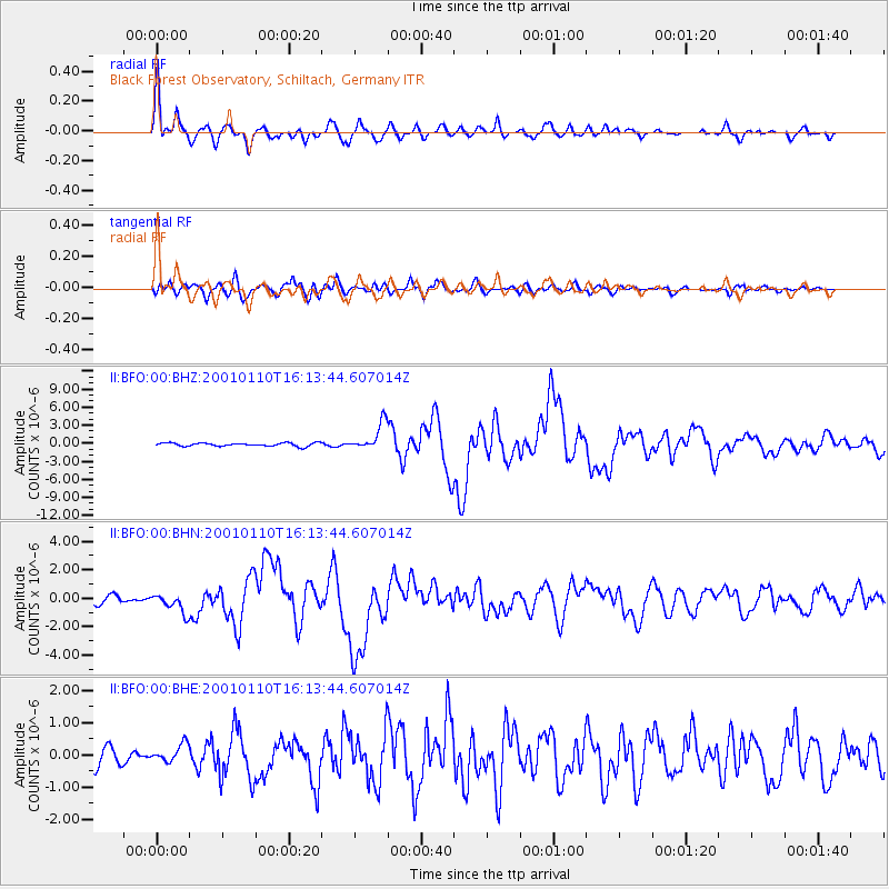
Earthquake location: Kodiak Island Region, Alaska
Earthquake latitude/longitude: 57.1/-153.2
Earthquake time(UTC): 2001/01/10 (010) 16:02:44 GMT
Earthquake Depth: 33 km
Earthquake Magnitude: 6.2 MB, 6.8 MS, 7.1 MW, 6.8 ML
Earthquake Catalog/Contributor: WHDF/NEIC
Network: II Global Seismograph Network (GSN - IRIS/IDA)
Station: BFO Black Forest Observatory, Schiltach, Germany
Lat/Lon: 48.33 N/8.33 E
Elevation: 589 m
Distance: 73.8 deg
Az: 12.707 deg
Baz: 349.63 deg
Ray Param: 0.052685816
Estimated Moho Depth: 26.0 km
Estimated Crust Vp/Vs: 1.73
Assumed Crust Vp: 6.264 km/s
Estimated Crust Vs: 3.631 km/s
Estimated Crust Poisson's Ratio: 0.25
Radial Match: 90.237495 %
Radial Bump: 400
Transverse Match: 83.63929 %
Transverse Bump: 400
SOD ConfigId: 3744
Insert Time: 2010-03-01 20:28:37.245 +0000
GWidth: 2.5
Max Bumps: 400
Tol: 0.001

Signal To Noise

ChannelStoNSTALTA
II:BFO:00:BHN:20010110T16:13:44.607014Z1.66359326.7431677E-74.0533754E-7
II:BFO:00:BHE:20010110T16:13:44.607014Z1.01161412.7437213E-72.7122215E-7
II:BFO:00:BHZ:20010110T16:13:44.607014Z8.2758172.2559086E-62.7259046E-7
Arrivals
Ps3.1 SECOND
PpPs11 SECOND
PsPs/PpSs14 SECOND