You are here: Home > Network List > TA - USArray Transportable Network (new EarthScope stations) Stations List
> Station J04D Umpqua National Forest, Toketee, OR, USA > Earthquake Result Viewer
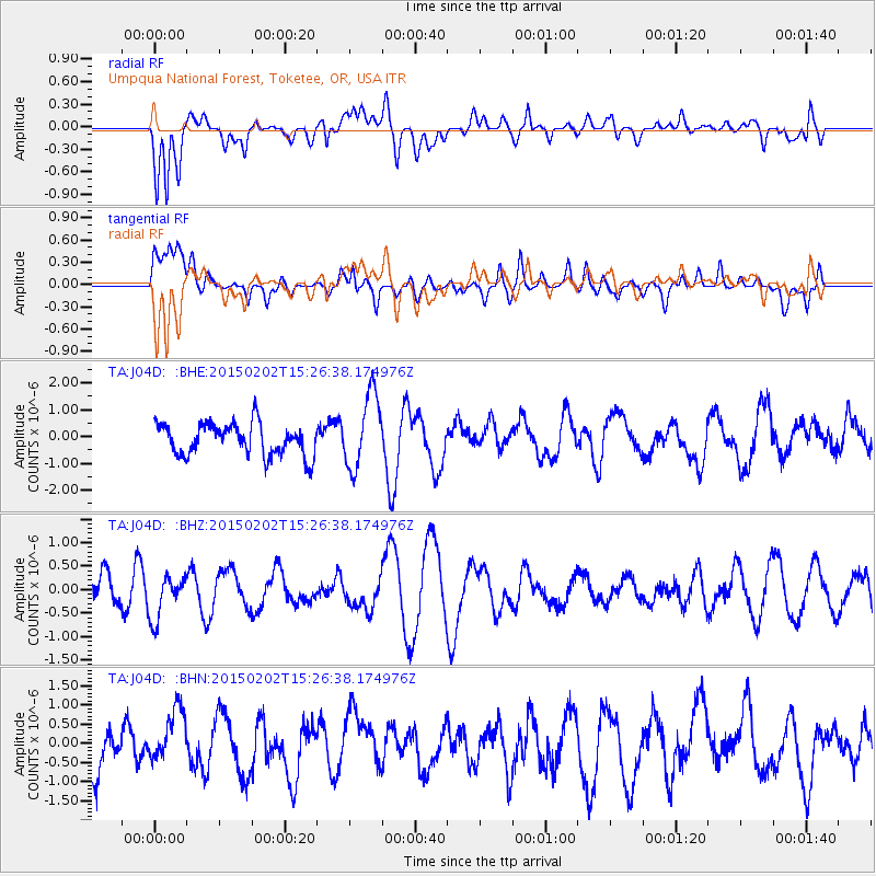
J04D Umpqua National Forest, Toketee, OR, USA - Earthquake Result Viewer
*The percent match for this event was below the threshold and hence no stack was calculated.
| Earthquake location: |
Luzon, Philippines |
| Earthquake latitude/longitude: |
13.9/124.6 |
| Earthquake time(UTC): |
2015/02/02 (033) 15:13:41 GMT |
| Earthquake Depth: |
28 km |
| Earthquake Magnitude: |
5.5 MW |
| Earthquake Catalog/Contributor: |
ISC/ISC |
|
| Network: |
TA USArray Transportable Network (new EarthScope stations) |
| Station: |
J04D Umpqua National Forest, Toketee, OR, USA |
| Lat/Lon: |
43.24 N/122.11 W |
| Elevation: |
1948 m |
|
| Distance: |
96.8 deg |
| Az: |
42.516 deg |
| Baz: |
296.091 deg |
| Ray Param: |
$rayparam |
*The percent match for this event was below the threshold and hence was not used in the summary stack. |
|
| Radial Match: |
64.74793 % |
| Radial Bump: |
400 |
| Transverse Match: |
32.469006 % |
| Transverse Bump: |
400 |
| SOD ConfigId: |
6990191 |
| Insert Time: |
2019-04-16 12:39:22.804 +0000 |
| GWidth: |
2.5 |
| Max Bumps: |
400 |
| Tol: |
0.001 |
|
Signal To Noise
| Channel | StoN | STA | LTA |
| TA:J04D: :BHZ:20150202T15:26:38.174976Z | 1.0951097 | 4.6780139E-7 | 4.271731E-7 |
| TA:J04D: :BHN:20150202T15:26:38.174976Z | 1.1299444 | 7.4366034E-7 | 6.5813884E-7 |
| TA:J04D: :BHE:20150202T15:26:38.174976Z | 2.363931 | 1.3998177E-6 | 5.921568E-7 |
| Arrivals |
| Ps | |
| PpPs | |
| PsPs/PpSs | |


