You are here: Home > Network List > TA - USArray Transportable Network (new EarthScope stations) Stations List
> Station G47A Hillman, MI, USA > Earthquake Result Viewer
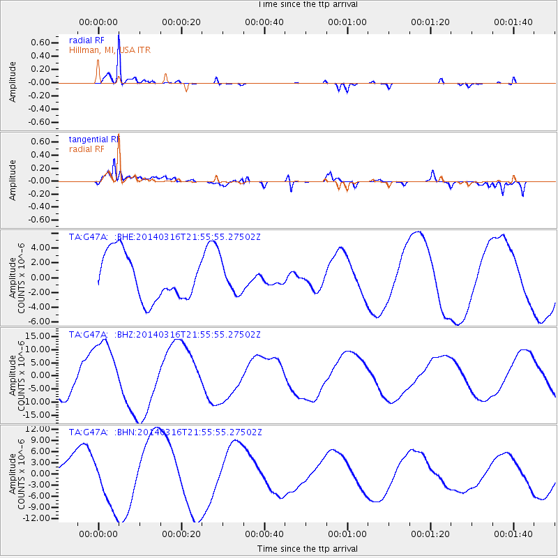
G47A Hillman, MI, USA - Earthquake Result Viewer
*The percent match for this event was below the threshold and hence no stack was calculated.
| Earthquake location: |
Southeast Of Shikoku, Japan |
| Earthquake latitude/longitude: |
29.4/133.7 |
| Earthquake time(UTC): |
2014/03/16 (075) 21:42:50 GMT |
| Earthquake Depth: |
16 km |
| Earthquake Magnitude: |
5.8 MB |
| Earthquake Catalog/Contributor: |
NEIC PDE/NEIC COMCAT |
|
| Network: |
TA USArray Transportable Network (new EarthScope stations) |
| Station: |
G47A Hillman, MI, USA |
| Lat/Lon: |
45.17 N/83.86 W |
| Elevation: |
239 m |
|
| Distance: |
98.3 deg |
| Az: |
25.833 deg |
| Baz: |
327.475 deg |
| Ray Param: |
$rayparam |
*The percent match for this event was below the threshold and hence was not used in the summary stack. |
|
| Radial Match: |
97.84796 % |
| Radial Bump: |
229 |
| Transverse Match: |
70.063675 % |
| Transverse Bump: |
400 |
| SOD ConfigId: |
626651 |
| Insert Time: |
2014-04-23 05:59:39.967 +0000 |
| GWidth: |
2.5 |
| Max Bumps: |
400 |
| Tol: |
0.001 |
|
Signal To Noise
| Channel | StoN | STA | LTA |
| TA:G47A: :BHZ:20140316T21:55:55.27502Z | 2.6759572 | 1.2373979E-5 | 4.6241316E-6 |
| TA:G47A: :BHN:20140316T21:55:55.27502Z | 1.5225812 | 7.63829E-6 | 5.0166723E-6 |
| TA:G47A: :BHE:20140316T21:55:55.27502Z | 0.6584422 | 1.998414E-6 | 3.0350636E-6 |
| Arrivals |
| Ps | |
| PpPs | |
| PsPs/PpSs | |


