You are here: Home > Network List > TA - USArray Transportable Network (new EarthScope stations) Stations List
> Station I45A Fountain, MI, USA > Earthquake Result Viewer
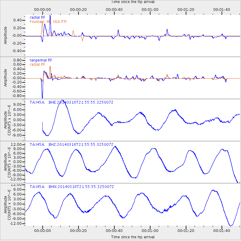
I45A Fountain, MI, USA - Earthquake Result Viewer
*The percent match for this event was below the threshold and hence no stack was calculated.
| Earthquake location: |
Southeast Of Shikoku, Japan |
| Earthquake latitude/longitude: |
29.4/133.7 |
| Earthquake time(UTC): |
2014/03/16 (075) 21:42:50 GMT |
| Earthquake Depth: |
16 km |
| Earthquake Magnitude: |
5.8 MB |
| Earthquake Catalog/Contributor: |
NEIC PDE/NEIC COMCAT |
|
| Network: |
TA USArray Transportable Network (new EarthScope stations) |
| Station: |
I45A Fountain, MI, USA |
| Lat/Lon: |
44.04 N/86.23 W |
| Elevation: |
215 m |
|
| Distance: |
98.3 deg |
| Az: |
27.899 deg |
| Baz: |
325.51 deg |
| Ray Param: |
$rayparam |
*The percent match for this event was below the threshold and hence was not used in the summary stack. |
|
| Radial Match: |
88.1837 % |
| Radial Bump: |
400 |
| Transverse Match: |
50.291805 % |
| Transverse Bump: |
400 |
| SOD ConfigId: |
626651 |
| Insert Time: |
2014-04-23 05:59:51.283 +0000 |
| GWidth: |
2.5 |
| Max Bumps: |
400 |
| Tol: |
0.001 |
|
Signal To Noise
| Channel | StoN | STA | LTA |
| TA:I45A: :BHZ:20140316T21:55:55.325007Z | 2.3322353 | 8.260663E-6 | 3.541951E-6 |
| TA:I45A: :BHN:20140316T21:55:55.325007Z | 1.3099084 | 4.2679217E-6 | 3.2581834E-6 |
| TA:I45A: :BHE:20140316T21:55:55.325007Z | 0.6244834 | 4.3449004E-6 | 6.9575913E-6 |
| Arrivals |
| Ps | |
| PpPs | |
| PsPs/PpSs | |


