You are here: Home > Network List > II - Global Seismograph Network (GSN - IRIS/IDA) Stations List
> Station BFO Black Forest Observatory, Schiltach, Germany > Earthquake Result Viewer
BFO Black Forest Observatory, Schiltach, Germany - Earthquake Result Viewer
| Earthquake location: |
Hindu Kush Region, Afghanistan |
| Earthquake latitude/longitude: |
36.5/70.5 |
| Earthquake time(UTC): |
2002/03/03 (062) 12:08:19 GMT |
| Earthquake Depth: |
226 km |
| Earthquake Magnitude: |
6.6 MB, 7.4 MW, 7.3 MW |
| Earthquake Catalog/Contributor: |
WHDF/NEIC |
|
| Network: |
II Global Seismograph Network (GSN - IRIS/IDA) |
| Station: |
BFO Black Forest Observatory, Schiltach, Germany |
| Lat/Lon: |
48.33 N/8.33 E |
| Elevation: |
589 m |
|
| Distance: |
46.2 deg |
| Az: |
305.152 deg |
| Baz: |
80.839 deg |
| Ray Param: |
0.06991818 |
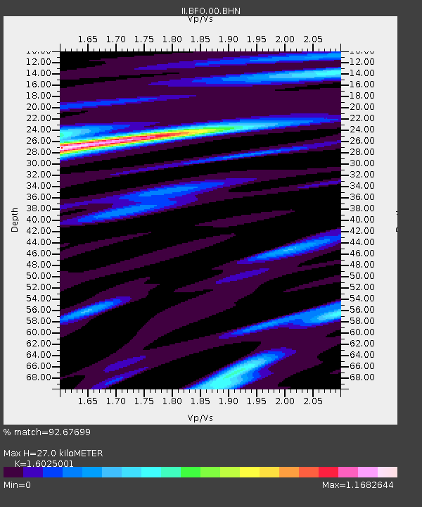
| Estimated Moho Depth: |
27.0 km |
| Estimated Crust Vp/Vs: |
1.60 |
| Assumed Crust Vp: |
6.264 km/s |
| Estimated Crust Vs: |
3.909 km/s |
| Estimated Crust Poisson's Ratio: |
0.18 |
|
| Radial Match: |
92.67699 % |
| Radial Bump: |
304 |
| Transverse Match: |
69.15798 % |
| Transverse Bump: |
400 |
| SOD ConfigId: |
20082 |
| Insert Time: |
2010-03-01 20:29:38.521 +0000 |
| GWidth: |
2.5 |
| Max Bumps: |
400 |
| Tol: |
0.001 |
|

Signal To Noise
| Channel | StoN | STA | LTA |
| II:BFO:00:BHN:20020303T12:15:51.358011Z | 8.892858 | 1.2672176E-6 | 1.4249835E-7 |
| II:BFO:00:BHE:20020303T12:15:51.358011Z | 12.682191 | 9.482798E-6 | 7.4772555E-7 |
| II:BFO:00:BHZ:20020303T12:15:51.358011Z | 12.331564 | 1.6999811E-5 | 1.3785609E-6 |
| Arrivals |
| Ps | 2.8 SECOND |
| PpPs | 11 SECOND |
| PsPs/PpSs | 13 SECOND |


