You are here: Home > Network List > TA - USArray Transportable Network (new EarthScope stations) Stations List
> Station P56A Dayton Farm, Ripley, WV, USA > Earthquake Result Viewer
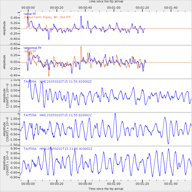
P56A Dayton Farm, Ripley, WV, USA - Earthquake Result Viewer
*The percent match for this event was below the threshold and hence no stack was calculated.
| Earthquake location: |
Near Coast Of Northern Chile |
| Earthquake latitude/longitude: |
-22.3/-70.9 |
| Earthquake time(UTC): |
2015/02/02 (033) 15:22:08 GMT |
| Earthquake Depth: |
14 km |
| Earthquake Magnitude: |
5.3 MW |
| Earthquake Catalog/Contributor: |
ISC/ISC |
|
| Network: |
TA USArray Transportable Network (new EarthScope stations) |
| Station: |
P56A Dayton Farm, Ripley, WV, USA |
| Lat/Lon: |
39.50 N/78.84 W |
| Elevation: |
249 m |
|
| Distance: |
62.0 deg |
| Az: |
353.012 deg |
| Baz: |
171.628 deg |
| Ray Param: |
$rayparam |
*The percent match for this event was below the threshold and hence was not used in the summary stack. |
|
| Radial Match: |
61.677555 % |
| Radial Bump: |
400 |
| Transverse Match: |
51.209835 % |
| Transverse Bump: |
400 |
| SOD ConfigId: |
7019011 |
| Insert Time: |
2019-04-16 15:18:19.887 +0000 |
| GWidth: |
2.5 |
| Max Bumps: |
400 |
| Tol: |
0.001 |
|
Signal To Noise
| Channel | StoN | STA | LTA |
| TA:P56A: :HHZ:20150202T15:31:56.920002Z | 1.0874127 | 5.183249E-7 | 4.7665887E-7 |
| TA:P56A: :HHN:20150202T15:31:56.920002Z | 0.6845281 | 3.5038258E-7 | 5.1186004E-7 |
| TA:P56A: :HHE:20150202T15:31:56.920002Z | 1.1146832 | 6.5518145E-7 | 5.8777374E-7 |
| Arrivals |
| Ps | |
| PpPs | |
| PsPs/PpSs | |


