You are here: Home > Network List > TA - USArray Transportable Network (new EarthScope stations) Stations List
> Station W60A Pink Hill, NC, USA > Earthquake Result Viewer
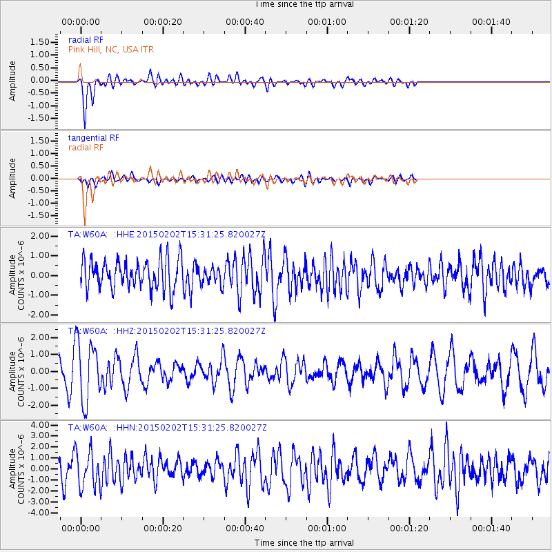
W60A Pink Hill, NC, USA - Earthquake Result Viewer
*The percent match for this event was below the threshold and hence no stack was calculated.
| Earthquake location: |
Near Coast Of Northern Chile |
| Earthquake latitude/longitude: |
-22.3/-70.9 |
| Earthquake time(UTC): |
2015/02/02 (033) 15:22:08 GMT |
| Earthquake Depth: |
14 km |
| Earthquake Magnitude: |
5.3 MW |
| Earthquake Catalog/Contributor: |
ISC/ISC |
|
| Network: |
TA USArray Transportable Network (new EarthScope stations) |
| Station: |
W60A Pink Hill, NC, USA |
| Lat/Lon: |
35.05 N/77.71 W |
| Elevation: |
30 m |
|
| Distance: |
57.4 deg |
| Az: |
353.33 deg |
| Baz: |
172.468 deg |
| Ray Param: |
$rayparam |
*The percent match for this event was below the threshold and hence was not used in the summary stack. |
|
| Radial Match: |
71.6709 % |
| Radial Bump: |
400 |
| Transverse Match: |
59.701397 % |
| Transverse Bump: |
400 |
| SOD ConfigId: |
7019011 |
| Insert Time: |
2019-04-16 15:18:34.641 +0000 |
| GWidth: |
2.5 |
| Max Bumps: |
400 |
| Tol: |
0.001 |
|
Signal To Noise
| Channel | StoN | STA | LTA |
| TA:W60A: :HHZ:20150202T15:31:25.820027Z | 2.944289 | 1.7502088E-6 | 5.9444193E-7 |
| TA:W60A: :HHN:20150202T15:31:25.820027Z | 1.5654702 | 1.5504332E-6 | 9.903946E-7 |
| TA:W60A: :HHE:20150202T15:31:25.820027Z | 0.585341 | 4.296749E-7 | 7.3405914E-7 |
| Arrivals |
| Ps | |
| PpPs | |
| PsPs/PpSs | |


