You are here: Home > Network List > TA - USArray Transportable Network (new EarthScope stations) Stations List
> Station O03E Paynes Creek, CA, USA > Earthquake Result Viewer
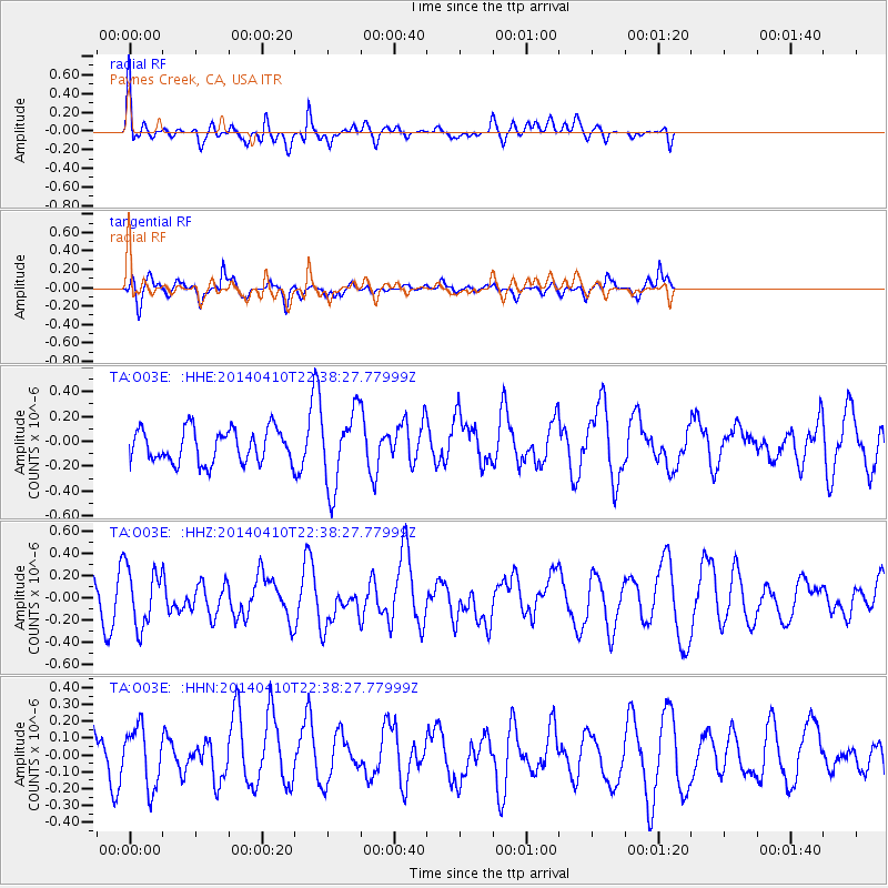
O03E Paynes Creek, CA, USA - Earthquake Result Viewer
*The percent match for this event was below the threshold and hence no stack was calculated.
| Earthquake location: |
Tonga Islands |
| Earthquake latitude/longitude: |
-19.2/-173.5 |
| Earthquake time(UTC): |
2014/04/10 (100) 22:27:10 GMT |
| Earthquake Depth: |
14 km |
| Earthquake Magnitude: |
5.6 MWP |
| Earthquake Catalog/Contributor: |
NEIC PDE/NEIC COMCAT |
|
| Network: |
TA USArray Transportable Network (new EarthScope stations) |
| Station: |
O03E Paynes Creek, CA, USA |
| Lat/Lon: |
40.29 N/121.80 W |
| Elevation: |
967 m |
|
| Distance: |
76.3 deg |
| Az: |
38.163 deg |
| Baz: |
229.752 deg |
| Ray Param: |
$rayparam |
*The percent match for this event was below the threshold and hence was not used in the summary stack. |
|
| Radial Match: |
61.966022 % |
| Radial Bump: |
400 |
| Transverse Match: |
69.33128 % |
| Transverse Bump: |
346 |
| SOD ConfigId: |
626651 |
| Insert Time: |
2014-04-24 23:13:36.392 +0000 |
| GWidth: |
2.5 |
| Max Bumps: |
400 |
| Tol: |
0.001 |
|
Signal To Noise
| Channel | StoN | STA | LTA |
| TA:O03E: :HHZ:20140410T22:38:27.77999Z | 1.5536046 | 2.6420946E-7 | 1.7006224E-7 |
| TA:O03E: :HHN:20140410T22:38:27.77999Z | 0.9268102 | 1.7799056E-7 | 1.9204639E-7 |
| TA:O03E: :HHE:20140410T22:38:27.77999Z | 2.282705 | 3.0602507E-7 | 1.3406247E-7 |
| Arrivals |
| Ps | |
| PpPs | |
| PsPs/PpSs | |


