You are here: Home > Network List > TA - USArray Transportable Network (new EarthScope stations) Stations List
> Station X43A Marvell, AR, USA > Earthquake Result Viewer
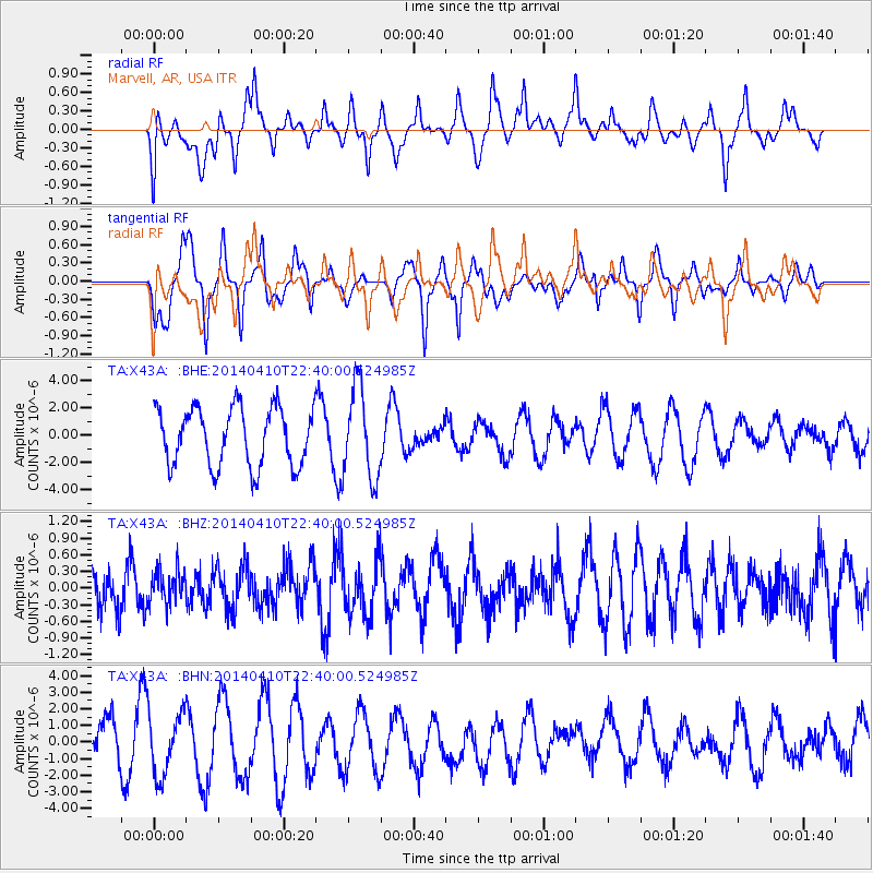
X43A Marvell, AR, USA - Earthquake Result Viewer
*The percent match for this event was below the threshold and hence no stack was calculated.
| Earthquake location: |
Tonga Islands |
| Earthquake latitude/longitude: |
-19.2/-173.5 |
| Earthquake time(UTC): |
2014/04/10 (100) 22:27:10 GMT |
| Earthquake Depth: |
14 km |
| Earthquake Magnitude: |
5.6 MWP |
| Earthquake Catalog/Contributor: |
NEIC PDE/NEIC COMCAT |
|
| Network: |
TA USArray Transportable Network (new EarthScope stations) |
| Station: |
X43A Marvell, AR, USA |
| Lat/Lon: |
34.52 N/90.88 W |
| Elevation: |
53 m |
|
| Distance: |
94.9 deg |
| Az: |
55.272 deg |
| Baz: |
250.115 deg |
| Ray Param: |
$rayparam |
*The percent match for this event was below the threshold and hence was not used in the summary stack. |
|
| Radial Match: |
49.481796 % |
| Radial Bump: |
400 |
| Transverse Match: |
39.822586 % |
| Transverse Bump: |
364 |
| SOD ConfigId: |
626651 |
| Insert Time: |
2014-04-24 23:14:04.438 +0000 |
| GWidth: |
2.5 |
| Max Bumps: |
400 |
| Tol: |
0.001 |
|
Signal To Noise
| Channel | StoN | STA | LTA |
| TA:X43A: :BHZ:20140410T22:40:00.524985Z | 0.7246926 | 3.0134683E-7 | 4.1582712E-7 |
| TA:X43A: :BHN:20140410T22:40:00.524985Z | 1.508205 | 1.8588621E-6 | 1.2324996E-6 |
| TA:X43A: :BHE:20140410T22:40:00.524985Z | 1.5731254 | 3.310966E-6 | 2.1047058E-6 |
| Arrivals |
| Ps | |
| PpPs | |
| PsPs/PpSs | |


