You are here: Home > Network List > TA - USArray Transportable Network (new EarthScope stations) Stations List
> Station A04D Lummi Island, WA, USA > Earthquake Result Viewer
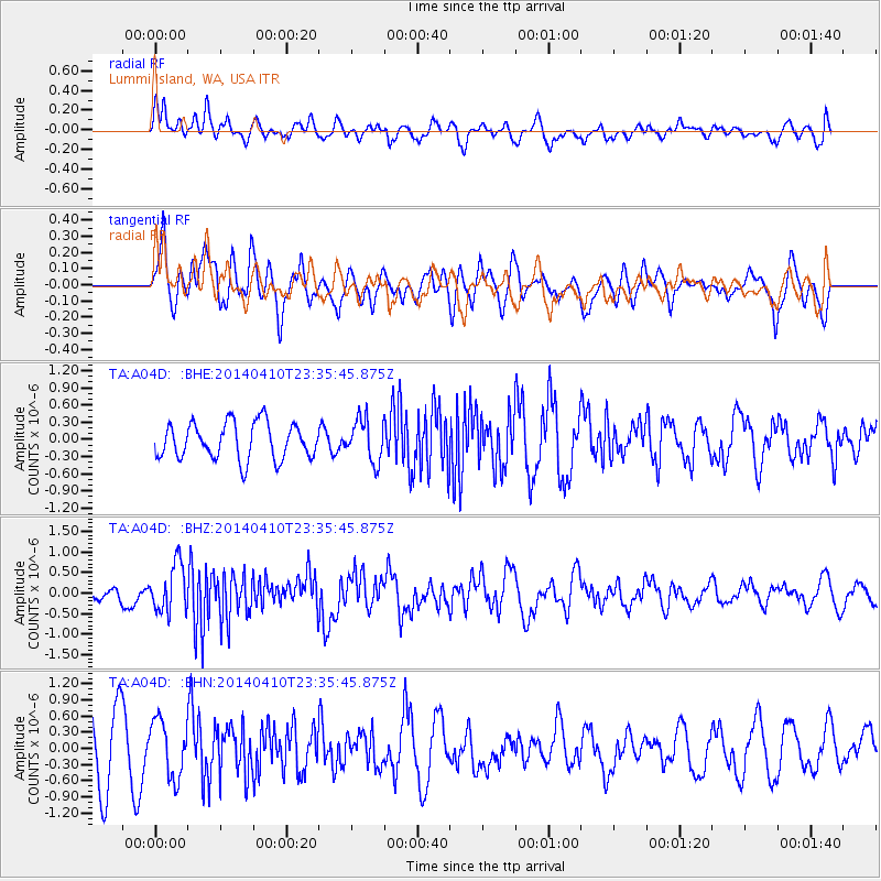
A04D Lummi Island, WA, USA - Earthquake Result Viewer
*The percent match for this event was below the threshold and hence no stack was calculated.
| Earthquake location: |
Nicaragua |
| Earthquake latitude/longitude: |
12.5/-86.4 |
| Earthquake time(UTC): |
2014/04/10 (100) 23:27:46 GMT |
| Earthquake Depth: |
13 km |
| Earthquake Magnitude: |
6.1 MWP, 6.0 MWB |
| Earthquake Catalog/Contributor: |
NEIC PDE/NEIC COMCAT |
|
| Network: |
TA USArray Transportable Network (new EarthScope stations) |
| Station: |
A04D Lummi Island, WA, USA |
| Lat/Lon: |
48.72 N/122.71 W |
| Elevation: |
13 m |
|
| Distance: |
47.0 deg |
| Az: |
327.544 deg |
| Baz: |
127.688 deg |
| Ray Param: |
$rayparam |
*The percent match for this event was below the threshold and hence was not used in the summary stack. |
|
| Radial Match: |
44.586655 % |
| Radial Bump: |
400 |
| Transverse Match: |
50.057854 % |
| Transverse Bump: |
400 |
| SOD ConfigId: |
626651 |
| Insert Time: |
2014-04-25 00:16:01.917 +0000 |
| GWidth: |
2.5 |
| Max Bumps: |
400 |
| Tol: |
0.001 |
|
Signal To Noise
| Channel | StoN | STA | LTA |
| TA:A04D: :BHZ:20140410T23:35:45.875Z | 2.9676523 | 5.792247E-7 | 1.9517944E-7 |
| TA:A04D: :BHN:20140410T23:35:45.875Z | 0.9417665 | 5.2667735E-7 | 5.592441E-7 |
| TA:A04D: :BHE:20140410T23:35:45.875Z | 1.1541951 | 3.6364818E-7 | 3.1506647E-7 |
| Arrivals |
| Ps | |
| PpPs | |
| PsPs/PpSs | |


