You are here: Home > Network List > TA - USArray Transportable Network (new EarthScope stations) Stations List
> Station D51A Lot 18 Range III Mazenod Township, QC, CAN > Earthquake Result Viewer
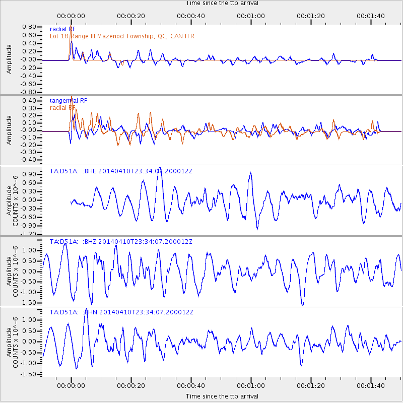
D51A Lot 18 Range III Mazenod Township, QC, CAN - Earthquake Result Viewer
*The percent match for this event was below the threshold and hence no stack was calculated.
| Earthquake location: |
Nicaragua |
| Earthquake latitude/longitude: |
12.5/-86.4 |
| Earthquake time(UTC): |
2014/04/10 (100) 23:27:46 GMT |
| Earthquake Depth: |
13 km |
| Earthquake Magnitude: |
6.1 MWP, 6.0 MWB |
| Earthquake Catalog/Contributor: |
NEIC PDE/NEIC COMCAT |
|
| Network: |
TA USArray Transportable Network (new EarthScope stations) |
| Station: |
D51A Lot 18 Range III Mazenod Township, QC, CAN |
| Lat/Lon: |
47.09 N/79.37 W |
| Elevation: |
282 m |
|
| Distance: |
35.0 deg |
| Az: |
8.361 deg |
| Baz: |
191.995 deg |
| Ray Param: |
$rayparam |
*The percent match for this event was below the threshold and hence was not used in the summary stack. |
|
| Radial Match: |
67.69003 % |
| Radial Bump: |
400 |
| Transverse Match: |
44.330307 % |
| Transverse Bump: |
400 |
| SOD ConfigId: |
626651 |
| Insert Time: |
2014-04-25 00:16:32.944 +0000 |
| GWidth: |
2.5 |
| Max Bumps: |
400 |
| Tol: |
0.001 |
|
Signal To Noise
| Channel | StoN | STA | LTA |
| TA:D51A: :BHZ:20140410T23:34:07.200012Z | 1.4843638 | 7.801654E-7 | 5.2558914E-7 |
| TA:D51A: :BHN:20140410T23:34:07.200012Z | 1.3342254 | 8.014982E-7 | 6.007217E-7 |
| TA:D51A: :BHE:20140410T23:34:07.200012Z | 2.196514 | 6.734797E-7 | 3.06613E-7 |
| Arrivals |
| Ps | |
| PpPs | |
| PsPs/PpSs | |


