You are here: Home > Network List > TA - USArray Transportable Network (new EarthScope stations) Stations List
> Station J01E Myrtle Point, OR, USA > Earthquake Result Viewer
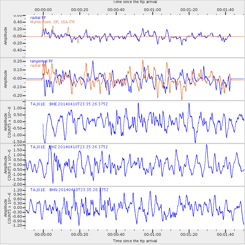
J01E Myrtle Point, OR, USA - Earthquake Result Viewer
*The percent match for this event was below the threshold and hence no stack was calculated.
| Earthquake location: |
Nicaragua |
| Earthquake latitude/longitude: |
12.5/-86.4 |
| Earthquake time(UTC): |
2014/04/10 (100) 23:27:46 GMT |
| Earthquake Depth: |
13 km |
| Earthquake Magnitude: |
6.1 MWP, 6.0 MWB |
| Earthquake Catalog/Contributor: |
NEIC PDE/NEIC COMCAT |
|
| Network: |
TA USArray Transportable Network (new EarthScope stations) |
| Station: |
J01E Myrtle Point, OR, USA |
| Lat/Lon: |
43.16 N/123.93 W |
| Elevation: |
128 m |
|
| Distance: |
44.5 deg |
| Az: |
320.486 deg |
| Baz: |
121.879 deg |
| Ray Param: |
$rayparam |
*The percent match for this event was below the threshold and hence was not used in the summary stack. |
|
| Radial Match: |
52.12693 % |
| Radial Bump: |
400 |
| Transverse Match: |
51.604088 % |
| Transverse Bump: |
400 |
| SOD ConfigId: |
626651 |
| Insert Time: |
2014-04-25 00:20:48.881 +0000 |
| GWidth: |
2.5 |
| Max Bumps: |
400 |
| Tol: |
0.001 |
|
Signal To Noise
| Channel | StoN | STA | LTA |
| TA:J01E: :BHZ:20140410T23:35:26.375Z | 2.285094 | 1.0412014E-6 | 4.556492E-7 |
| TA:J01E: :BHN:20140410T23:35:26.375Z | 0.9163501 | 3.6117663E-7 | 3.9414695E-7 |
| TA:J01E: :BHE:20140410T23:35:26.375Z | 0.6504504 | 3.9678537E-7 | 6.100163E-7 |
| Arrivals |
| Ps | |
| PpPs | |
| PsPs/PpSs | |


