You are here: Home > Network List > TA - USArray Transportable Network (new EarthScope stations) Stations List
> Station J01E Myrtle Point, OR, USA > Earthquake Result Viewer
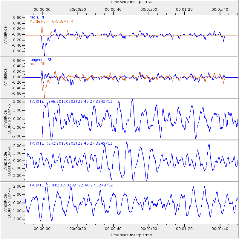
J01E Myrtle Point, OR, USA - Earthquake Result Viewer
*The percent match for this event was below the threshold and hence no stack was calculated.
| Earthquake location: |
South Of Kermadec Islands |
| Earthquake latitude/longitude: |
-33.2/180.0 |
| Earthquake time(UTC): |
2015/02/02 (033) 22:34:14 GMT |
| Earthquake Depth: |
200 km |
| Earthquake Magnitude: |
4.5 mb |
| Earthquake Catalog/Contributor: |
ISC/ISC |
|
| Network: |
TA USArray Transportable Network (new EarthScope stations) |
| Station: |
J01E Myrtle Point, OR, USA |
| Lat/Lon: |
43.16 N/123.93 W |
| Elevation: |
128 m |
|
| Distance: |
91.7 deg |
| Az: |
37.401 deg |
| Baz: |
224.101 deg |
| Ray Param: |
$rayparam |
*The percent match for this event was below the threshold and hence was not used in the summary stack. |
|
| Radial Match: |
60.82977 % |
| Radial Bump: |
400 |
| Transverse Match: |
44.617886 % |
| Transverse Bump: |
400 |
| SOD ConfigId: |
7019011 |
| Insert Time: |
2019-04-16 15:23:56.810 +0000 |
| GWidth: |
2.5 |
| Max Bumps: |
400 |
| Tol: |
0.001 |
|
Signal To Noise
| Channel | StoN | STA | LTA |
| TA:J01E: :BHZ:20150202T22:46:27.324971Z | 0.81543845 | 6.216891E-7 | 7.6239854E-7 |
| TA:J01E: :BHN:20150202T22:46:27.324971Z | 3.1085932 | 1.4120651E-6 | 4.542457E-7 |
| TA:J01E: :BHE:20150202T22:46:27.324971Z | 0.874402 | 8.2315023E-7 | 9.413865E-7 |
| Arrivals |
| Ps | |
| PpPs | |
| PsPs/PpSs | |


