You are here: Home > Network List > TA - USArray Transportable Network (new EarthScope stations) Stations List
> Station Q50A Georgetown, OH, USA > Earthquake Result Viewer
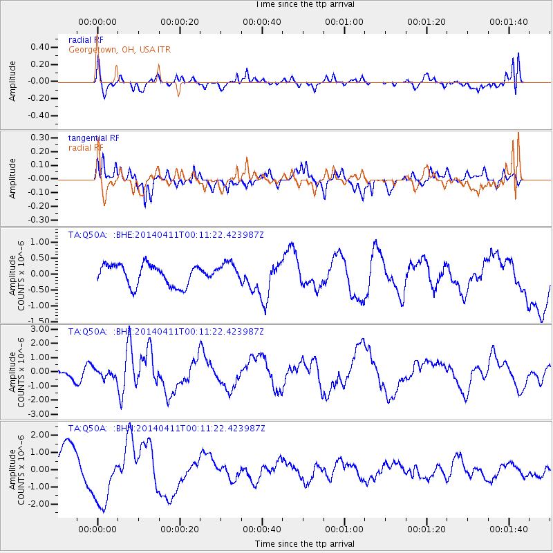
Q50A Georgetown, OH, USA - Earthquake Result Viewer
*The percent match for this event was below the threshold and hence no stack was calculated.
| Earthquake location: |
Near Coast Of Northern Chile |
| Earthquake latitude/longitude: |
-20.7/-70.7 |
| Earthquake time(UTC): |
2014/04/11 (101) 00:01:44 GMT |
| Earthquake Depth: |
18 km |
| Earthquake Magnitude: |
6.0 MB |
| Earthquake Catalog/Contributor: |
NEIC PDE/NEIC COMCAT |
|
| Network: |
TA USArray Transportable Network (new EarthScope stations) |
| Station: |
Q50A Georgetown, OH, USA |
| Lat/Lon: |
38.84 N/83.98 W |
| Elevation: |
262 m |
|
| Distance: |
60.6 deg |
| Az: |
348.136 deg |
| Baz: |
165.736 deg |
| Ray Param: |
$rayparam |
*The percent match for this event was below the threshold and hence was not used in the summary stack. |
|
| Radial Match: |
41.495697 % |
| Radial Bump: |
345 |
| Transverse Match: |
74.35379 % |
| Transverse Bump: |
395 |
| SOD ConfigId: |
626651 |
| Insert Time: |
2014-04-25 00:58:36.378 +0000 |
| GWidth: |
2.5 |
| Max Bumps: |
400 |
| Tol: |
0.001 |
|
Signal To Noise
| Channel | StoN | STA | LTA |
| TA:Q50A: :BHZ:20140411T00:11:22.423987Z | 0.50841314 | 3.1248766E-7 | 6.1463334E-7 |
| TA:Q50A: :BHN:20140411T00:11:22.423987Z | 1.6630841 | 1.7043253E-6 | 1.0247979E-6 |
| TA:Q50A: :BHE:20140411T00:11:22.423987Z | 0.9402879 | 3.1536698E-7 | 3.3539408E-7 |
| Arrivals |
| Ps | |
| PpPs | |
| PsPs/PpSs | |


