You are here: Home > Network List > TA - USArray Transportable Network (new EarthScope stations) Stations List
> Station R55A Marlinton, WV, USA > Earthquake Result Viewer
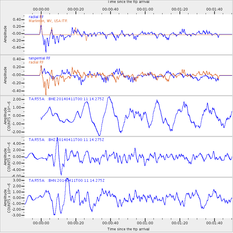
R55A Marlinton, WV, USA - Earthquake Result Viewer
*The percent match for this event was below the threshold and hence no stack was calculated.
| Earthquake location: |
Near Coast Of Northern Chile |
| Earthquake latitude/longitude: |
-20.7/-70.7 |
| Earthquake time(UTC): |
2014/04/11 (101) 00:01:44 GMT |
| Earthquake Depth: |
18 km |
| Earthquake Magnitude: |
6.0 MB |
| Earthquake Catalog/Contributor: |
NEIC PDE/NEIC COMCAT |
|
| Network: |
TA USArray Transportable Network (new EarthScope stations) |
| Station: |
R55A Marlinton, WV, USA |
| Lat/Lon: |
38.28 N/80.12 W |
| Elevation: |
833 m |
|
| Distance: |
59.4 deg |
| Az: |
351.414 deg |
| Baz: |
169.773 deg |
| Ray Param: |
$rayparam |
*The percent match for this event was below the threshold and hence was not used in the summary stack. |
|
| Radial Match: |
58.367134 % |
| Radial Bump: |
400 |
| Transverse Match: |
59.90796 % |
| Transverse Bump: |
400 |
| SOD ConfigId: |
626651 |
| Insert Time: |
2014-04-25 00:59:01.993 +0000 |
| GWidth: |
2.5 |
| Max Bumps: |
400 |
| Tol: |
0.001 |
|
Signal To Noise
| Channel | StoN | STA | LTA |
| TA:R55A: :BHZ:20140411T00:11:14.275Z | 1.0079036 | 4.6881976E-7 | 4.651435E-7 |
| TA:R55A: :BHN:20140411T00:11:14.275Z | 1.1847953 | 7.9297627E-7 | 6.6929397E-7 |
| TA:R55A: :BHE:20140411T00:11:14.275Z | 2.9838727 | 1.6078392E-6 | 5.388431E-7 |
| Arrivals |
| Ps | |
| PpPs | |
| PsPs/PpSs | |


