You are here: Home > Network List > TA - USArray Transportable Network (new EarthScope stations) Stations List
> Station S53A Williamson, WV, USA > Earthquake Result Viewer
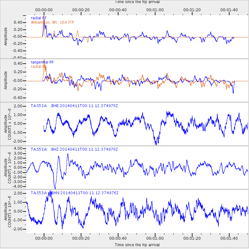
S53A Williamson, WV, USA - Earthquake Result Viewer
*The percent match for this event was below the threshold and hence no stack was calculated.
| Earthquake location: |
Near Coast Of Northern Chile |
| Earthquake latitude/longitude: |
-20.7/-70.7 |
| Earthquake time(UTC): |
2014/04/11 (101) 00:01:44 GMT |
| Earthquake Depth: |
18 km |
| Earthquake Magnitude: |
6.0 MB |
| Earthquake Catalog/Contributor: |
NEIC PDE/NEIC COMCAT |
|
| Network: |
TA USArray Transportable Network (new EarthScope stations) |
| Station: |
S53A Williamson, WV, USA |
| Lat/Lon: |
37.68 N/82.13 W |
| Elevation: |
564 m |
|
| Distance: |
59.1 deg |
| Az: |
349.467 deg |
| Baz: |
167.547 deg |
| Ray Param: |
$rayparam |
*The percent match for this event was below the threshold and hence was not used in the summary stack. |
|
| Radial Match: |
61.20481 % |
| Radial Bump: |
400 |
| Transverse Match: |
70.15284 % |
| Transverse Bump: |
400 |
| SOD ConfigId: |
626651 |
| Insert Time: |
2014-04-25 00:59:22.574 +0000 |
| GWidth: |
2.5 |
| Max Bumps: |
400 |
| Tol: |
0.001 |
|
Signal To Noise
| Channel | StoN | STA | LTA |
| TA:S53A: :BHZ:20140411T00:11:12.374976Z | 1.3581195 | 1.0084752E-6 | 7.4255263E-7 |
| TA:S53A: :BHN:20140411T00:11:12.374976Z | 2.05737 | 1.4330772E-6 | 6.965579E-7 |
| TA:S53A: :BHE:20140411T00:11:12.374976Z | 0.8207543 | 5.1119855E-7 | 6.228399E-7 |
| Arrivals |
| Ps | |
| PpPs | |
| PsPs/PpSs | |


