You are here: Home > Network List > TA - USArray Transportable Network (new EarthScope stations) Stations List
> Station T54A Tazewell, VA, USA > Earthquake Result Viewer
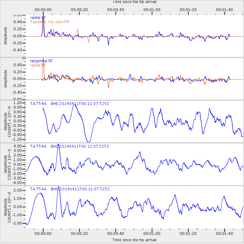
T54A Tazewell, VA, USA - Earthquake Result Viewer
*The percent match for this event was below the threshold and hence no stack was calculated.
| Earthquake location: |
Near Coast Of Northern Chile |
| Earthquake latitude/longitude: |
-20.7/-70.7 |
| Earthquake time(UTC): |
2014/04/11 (101) 00:01:44 GMT |
| Earthquake Depth: |
18 km |
| Earthquake Magnitude: |
6.0 MB |
| Earthquake Catalog/Contributor: |
NEIC PDE/NEIC COMCAT |
|
| Network: |
TA USArray Transportable Network (new EarthScope stations) |
| Station: |
T54A Tazewell, VA, USA |
| Lat/Lon: |
37.06 N/81.58 W |
| Elevation: |
852 m |
|
| Distance: |
58.4 deg |
| Az: |
349.815 deg |
| Baz: |
168.06 deg |
| Ray Param: |
$rayparam |
*The percent match for this event was below the threshold and hence was not used in the summary stack. |
|
| Radial Match: |
45.293076 % |
| Radial Bump: |
400 |
| Transverse Match: |
42.428646 % |
| Transverse Bump: |
400 |
| SOD ConfigId: |
626651 |
| Insert Time: |
2014-04-25 00:59:51.844 +0000 |
| GWidth: |
2.5 |
| Max Bumps: |
400 |
| Tol: |
0.001 |
|
Signal To Noise
| Channel | StoN | STA | LTA |
| TA:T54A: :BHZ:20140411T00:11:07.525Z | 1.558314 | 1.2322386E-6 | 7.907512E-7 |
| TA:T54A: :BHN:20140411T00:11:07.525Z | 1.1387465 | 1.0553026E-6 | 9.2672303E-7 |
| TA:T54A: :BHE:20140411T00:11:07.525Z | 0.53350747 | 3.285041E-7 | 6.157441E-7 |
| Arrivals |
| Ps | |
| PpPs | |
| PsPs/PpSs | |


