You are here: Home > Network List > II - Global Seismograph Network (GSN - IRIS/IDA) Stations List
> Station BFO Black Forest Observatory, Schiltach, Germany > Earthquake Result Viewer
BFO Black Forest Observatory, Schiltach, Germany - Earthquake Result Viewer
| Earthquake location: |
Mid-Indian Ridge |
| Earthquake latitude/longitude: |
-27.7/73.8 |
| Earthquake time(UTC): |
2005/03/14 (073) 05:11:57 GMT |
| Earthquake Depth: |
10 km |
| Earthquake Magnitude: |
5.6 MB, 5.4 MS, 5.6 MW, 5.4 MW |
| Earthquake Catalog/Contributor: |
WHDF/NEIC |
|
| Network: |
II Global Seismograph Network (GSN - IRIS/IDA) |
| Station: |
BFO Black Forest Observatory, Schiltach, Germany |
| Lat/Lon: |
48.33 N/8.33 E |
| Elevation: |
589 m |
|
| Distance: |
95.7 deg |
| Az: |
322.394 deg |
| Baz: |
125.85 deg |
| Ray Param: |
0.040710304 |
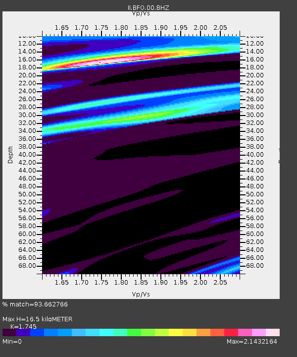
| Estimated Moho Depth: |
16.5 km |
| Estimated Crust Vp/Vs: |
1.75 |
| Assumed Crust Vp: |
6.264 km/s |
| Estimated Crust Vs: |
3.589 km/s |
| Estimated Crust Poisson's Ratio: |
0.26 |
|
| Radial Match: |
93.662766 % |
| Radial Bump: |
378 |
| Transverse Match: |
59.623043 % |
| Transverse Bump: |
400 |
| SOD ConfigId: |
2455 |
| Insert Time: |
2010-03-01 20:32:25.044 +0000 |
| GWidth: |
2.5 |
| Max Bumps: |
400 |
| Tol: |
0.001 |
|

Signal To Noise
| Channel | StoN | STA | LTA |
| II:BFO:00:BHN:20050314T05:24:51.685027Z | 1.2927638 | 7.166072E-7 | 5.543218E-7 |
| II:BFO:00:BHE:20050314T05:24:51.685027Z | 1.2427804 | 1.711152E-6 | 1.3768739E-6 |
| II:BFO:00:BHZ:20050314T05:24:51.685027Z | 1.3302008 | 1.8090525E-6 | 1.3599845E-6 |
| Arrivals |
| Ps | 2.0 SECOND |
| PpPs | 7.1 SECOND |
| PsPs/PpSs | 9.1 SECOND |


