You are here: Home > Network List > AE - Arizona Broadband Seismic Network Stations List
> Station X16A Lo Mia Camp, Pine, AZ, USA > Earthquake Result Viewer
X16A Lo Mia Camp, Pine, AZ, USA - Earthquake Result Viewer
| Earthquake location: |
Solomon Islands |
| Earthquake latitude/longitude: |
-6.6/155.1 |
| Earthquake time(UTC): |
2014/04/11 (101) 07:07:21 GMT |
| Earthquake Depth: |
50 km |
| Earthquake Magnitude: |
7.1 MWW, 7.0 MWB, 7.3 MI |
| Earthquake Catalog/Contributor: |
NEIC PDE/NEIC COMCAT |
|
| Network: |
AE Arizona Broadband Seismic Network |
| Station: |
X16A Lo Mia Camp, Pine, AZ, USA |
| Lat/Lon: |
34.42 N/111.44 W |
| Elevation: |
1759 m |
|
| Distance: |
96.6 deg |
| Az: |
56.164 deg |
| Baz: |
266.499 deg |
| Ray Param: |
0.04044181 |
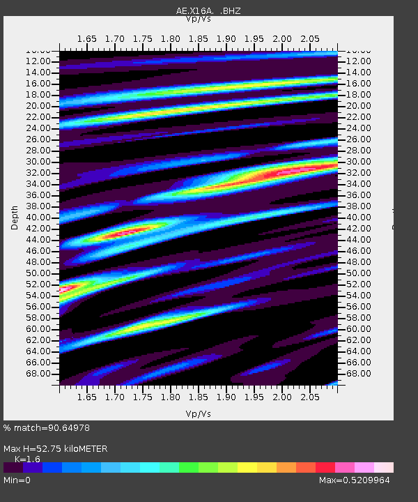
| Estimated Moho Depth: |
52.75 km |
| Estimated Crust Vp/Vs: |
1.60 |
| Assumed Crust Vp: |
6.207 km/s |
| Estimated Crust Vs: |
3.879 km/s |
| Estimated Crust Poisson's Ratio: |
0.18 |
|
| Radial Match: |
90.64978 % |
| Radial Bump: |
400 |
| Transverse Match: |
74.25645 % |
| Transverse Bump: |
400 |
| SOD ConfigId: |
626651 |
| Insert Time: |
2014-04-25 07:31:56.762 +0000 |
| GWidth: |
2.5 |
| Max Bumps: |
400 |
| Tol: |
0.001 |
|

Signal To Noise
| Channel | StoN | STA | LTA |
| AE:X16A: :BHZ:20140411T07:20:14.949971Z | 7.056017 | 7.5904023E-7 | 1.0757347E-7 |
| AE:X16A: :BHN:20140411T07:20:14.949971Z | 0.50558084 | 1.02119934E-7 | 2.0198537E-7 |
| AE:X16A: :BHE:20140411T07:20:14.949971Z | 1.4325988 | 2.1033327E-7 | 1.4681937E-7 |
| Arrivals |
| Ps | 5.2 SECOND |
| PpPs | 22 SECOND |
| PsPs/PpSs | 27 SECOND |


