You are here: Home > Network List > AK - Alaska Regional Network Stations List
> Station CCB Clear Creek Butte > Earthquake Result Viewer
CCB Clear Creek Butte - Earthquake Result Viewer
| Earthquake location: |
Solomon Islands |
| Earthquake latitude/longitude: |
-6.6/155.1 |
| Earthquake time(UTC): |
2014/04/11 (101) 07:07:21 GMT |
| Earthquake Depth: |
50 km |
| Earthquake Magnitude: |
7.1 MWW, 7.0 MWB, 7.3 MI |
| Earthquake Catalog/Contributor: |
NEIC PDE/NEIC COMCAT |
|
| Network: |
AK Alaska Regional Network |
| Station: |
CCB Clear Creek Butte |
| Lat/Lon: |
64.65 N/147.80 W |
| Elevation: |
248 m |
|
| Distance: |
82.6 deg |
| Az: |
21.388 deg |
| Baz: |
237.288 deg |
| Ray Param: |
0.04668385 |
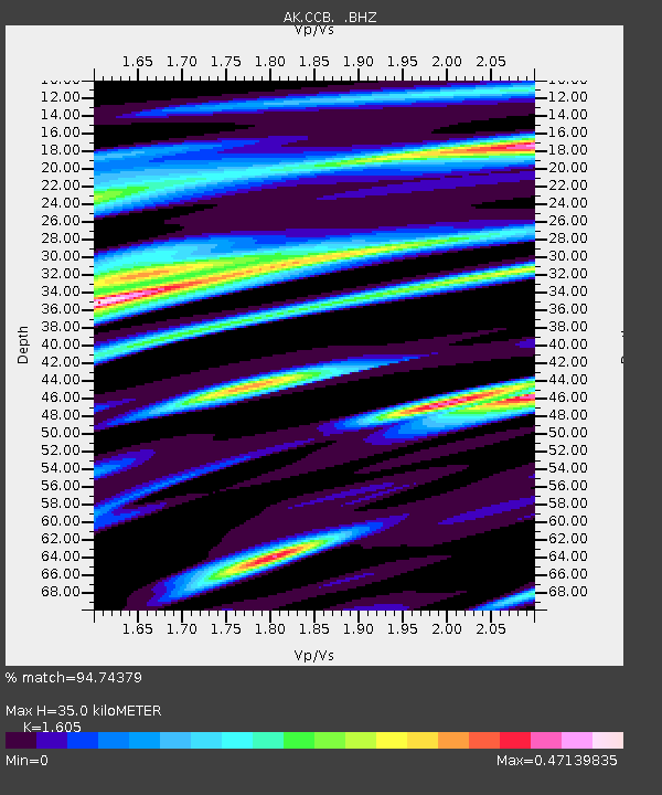
| Estimated Moho Depth: |
35.0 km |
| Estimated Crust Vp/Vs: |
1.61 |
| Assumed Crust Vp: |
6.566 km/s |
| Estimated Crust Vs: |
4.091 km/s |
| Estimated Crust Poisson's Ratio: |
0.18 |
|
| Radial Match: |
94.74379 % |
| Radial Bump: |
345 |
| Transverse Match: |
88.68408 % |
| Transverse Bump: |
400 |
| SOD ConfigId: |
626651 |
| Insert Time: |
2014-04-25 07:32:32.493 +0000 |
| GWidth: |
2.5 |
| Max Bumps: |
400 |
| Tol: |
0.001 |
|

Signal To Noise
| Channel | StoN | STA | LTA |
| AK:CCB: :BHZ:20140411T07:19:08.708027Z | 65.65252 | 5.597632E-6 | 8.52615E-8 |
| AK:CCB: :BHN:20140411T07:19:08.708027Z | 10.606208 | 1.1416635E-6 | 1.0764105E-7 |
| AK:CCB: :BHE:20140411T07:19:08.708027Z | 27.779947 | 1.6711657E-6 | 6.015727E-8 |
| Arrivals |
| Ps | 3.3 SECOND |
| PpPs | 13 SECOND |
| PsPs/PpSs | 17 SECOND |


