You are here: Home > Network List > AK - Alaska Regional Network Stations List
> Station HIN Hinchinbrook, AK, USA > Earthquake Result Viewer
HIN Hinchinbrook, AK, USA - Earthquake Result Viewer
| Earthquake location: |
Solomon Islands |
| Earthquake latitude/longitude: |
-6.6/155.1 |
| Earthquake time(UTC): |
2014/04/11 (101) 07:07:21 GMT |
| Earthquake Depth: |
50 km |
| Earthquake Magnitude: |
7.1 MWW, 7.0 MWB, 7.3 MI |
| Earthquake Catalog/Contributor: |
NEIC PDE/NEIC COMCAT |
|
| Network: |
AK Alaska Regional Network |
| Station: |
HIN Hinchinbrook, AK, USA |
| Lat/Lon: |
60.40 N/146.50 W |
| Elevation: |
633 m |
|
| Distance: |
80.9 deg |
| Az: |
25.371 deg |
| Baz: |
239.013 deg |
| Ray Param: |
0.047897723 |
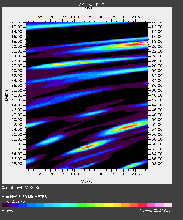
| Estimated Moho Depth: |
18.25 km |
| Estimated Crust Vp/Vs: |
2.10 |
| Assumed Crust Vp: |
6.566 km/s |
| Estimated Crust Vs: |
3.13 km/s |
| Estimated Crust Poisson's Ratio: |
0.35 |
|
| Radial Match: |
92.28695 % |
| Radial Bump: |
400 |
| Transverse Match: |
85.60371 % |
| Transverse Bump: |
400 |
| SOD ConfigId: |
626651 |
| Insert Time: |
2014-04-25 07:33:24.112 +0000 |
| GWidth: |
2.5 |
| Max Bumps: |
400 |
| Tol: |
0.001 |
|

Signal To Noise
| Channel | StoN | STA | LTA |
| AK:HIN: :BHZ:20140411T07:18:59.587971Z | 38.28319 | 7.407125E-6 | 1.9348244E-7 |
| AK:HIN: :BHN:20140411T07:18:59.587971Z | 11.216082 | 2.5073543E-6 | 2.2354995E-7 |
| AK:HIN: :BHE:20140411T07:18:59.587971Z | 7.25334 | 1.8375697E-6 | 2.533412E-7 |
| Arrivals |
| Ps | 3.1 SECOND |
| PpPs | 8.4 SECOND |
| PsPs/PpSs | 12 SECOND |


