You are here: Home > Network List > AK - Alaska Regional Network Stations List
> Station RAG Ragged Mountain > Earthquake Result Viewer
RAG Ragged Mountain - Earthquake Result Viewer
| Earthquake location: |
Solomon Islands |
| Earthquake latitude/longitude: |
-6.6/155.1 |
| Earthquake time(UTC): |
2014/04/11 (101) 07:07:21 GMT |
| Earthquake Depth: |
50 km |
| Earthquake Magnitude: |
7.1 MWW, 7.0 MWB, 7.3 MI |
| Earthquake Catalog/Contributor: |
NEIC PDE/NEIC COMCAT |
|
| Network: |
AK Alaska Regional Network |
| Station: |
RAG Ragged Mountain |
| Lat/Lon: |
60.39 N/144.68 W |
| Elevation: |
771 m |
|
| Distance: |
81.6 deg |
| Az: |
25.84 deg |
| Baz: |
240.671 deg |
| Ray Param: |
0.047350906 |
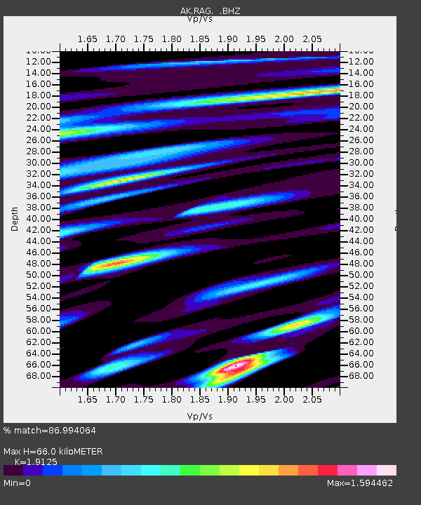
| Estimated Moho Depth: |
66.0 km |
| Estimated Crust Vp/Vs: |
1.91 |
| Assumed Crust Vp: |
6.566 km/s |
| Estimated Crust Vs: |
3.433 km/s |
| Estimated Crust Poisson's Ratio: |
0.31 |
|
| Radial Match: |
86.994064 % |
| Radial Bump: |
400 |
| Transverse Match: |
77.65164 % |
| Transverse Bump: |
400 |
| SOD ConfigId: |
626651 |
| Insert Time: |
2014-04-25 07:34:12.148 +0000 |
| GWidth: |
2.5 |
| Max Bumps: |
400 |
| Tol: |
0.001 |
|

Signal To Noise
| Channel | StoN | STA | LTA |
| AK:RAG: :BHZ:20140411T07:19:03.708027Z | 35.383255 | 6.681433E-6 | 1.8883037E-7 |
| AK:RAG: :BHN:20140411T07:19:03.708027Z | 8.927456 | 3.198272E-6 | 3.582512E-7 |
| AK:RAG: :BHE:20140411T07:19:03.708027Z | 8.909324 | 2.6737132E-6 | 3.0010284E-7 |
| Arrivals |
| Ps | 9.4 SECOND |
| PpPs | 29 SECOND |
| PsPs/PpSs | 38 SECOND |


