You are here: Home > Network List > AK - Alaska Regional Network Stations List
> Station UNV Unalaska Valley > Earthquake Result Viewer
UNV Unalaska Valley - Earthquake Result Viewer
| Earthquake location: |
Solomon Islands |
| Earthquake latitude/longitude: |
-6.6/155.1 |
| Earthquake time(UTC): |
2014/04/11 (101) 07:07:21 GMT |
| Earthquake Depth: |
50 km |
| Earthquake Magnitude: |
7.1 MWW, 7.0 MWB, 7.3 MI |
| Earthquake Catalog/Contributor: |
NEIC PDE/NEIC COMCAT |
|
| Network: |
AK Alaska Regional Network |
| Station: |
UNV Unalaska Valley |
| Lat/Lon: |
53.85 N/166.50 W |
| Elevation: |
67 m |
|
| Distance: |
68.4 deg |
| Az: |
23.344 deg |
| Baz: |
221.632 deg |
| Ray Param: |
0.056253724 |
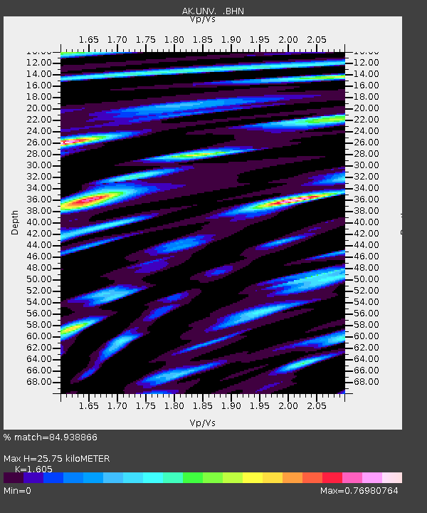
| Estimated Moho Depth: |
25.75 km |
| Estimated Crust Vp/Vs: |
1.61 |
| Assumed Crust Vp: |
3.943 km/s |
| Estimated Crust Vs: |
2.457 km/s |
| Estimated Crust Poisson's Ratio: |
0.18 |
|
| Radial Match: |
84.938866 % |
| Radial Bump: |
400 |
| Transverse Match: |
84.51017 % |
| Transverse Bump: |
400 |
| SOD ConfigId: |
626651 |
| Insert Time: |
2014-04-25 07:34:51.063 +0000 |
| GWidth: |
2.5 |
| Max Bumps: |
400 |
| Tol: |
0.001 |
|

Signal To Noise
| Channel | StoN | STA | LTA |
| AK:UNV: :BHZ:20140411T07:17:47.360005Z | 9.496606 | 4.7095796E-6 | 4.959224E-7 |
| AK:UNV: :BHN:20140411T07:17:47.360005Z | 4.433642 | 2.0522689E-6 | 4.628856E-7 |
| AK:UNV: :BHE:20140411T07:17:47.360005Z | 2.562726 | 1.1886804E-6 | 4.6383437E-7 |
| Arrivals |
| Ps | 4.0 SECOND |
| PpPs | 17 SECOND |
| PsPs/PpSs | 21 SECOND |


