You are here: Home > Network List > AK - Alaska Regional Network Stations List
> Station WAT5 Susitna Watana 5, AK, USA > Earthquake Result Viewer
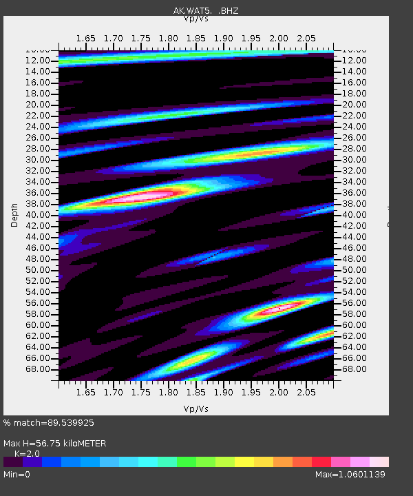
WAT5 Susitna Watana 5, AK, USA - Earthquake Result Viewer
| Earthquake location: |
Solomon Islands |
| Earthquake latitude/longitude: |
-6.6/155.1 |
| Earthquake time(UTC): |
2014/04/11 (101) 07:07:21 GMT |
| Earthquake Depth: |
50 km |
| Earthquake Magnitude: |
7.1 MWW, 7.0 MWB, 7.3 MI |
| Earthquake Catalog/Contributor: |
NEIC PDE/NEIC COMCAT |
|
| Network: |
AK Alaska Regional Network |
| Station: |
WAT5 Susitna Watana 5, AK, USA |
| Lat/Lon: |
63.06 N/148.23 W |
| Elevation: |
1691 m |
|
| Distance: |
81.6 deg |
| Az: |
22.634 deg |
| Baz: |
237.077 deg |
| Ray Param: |
0.047393654 |
| Estimated Moho Depth: |
56.75 km |
| Estimated Crust Vp/Vs: |
2.00 |
| Assumed Crust Vp: |
6.566 km/s |
| Estimated Crust Vs: |
3.283 km/s |
| Estimated Crust Poisson's Ratio: |
0.33 |
|
| Radial Match: |
89.539925 % |
| Radial Bump: |
310 |
| Transverse Match: |
87.46026 % |
| Transverse Bump: |
400 |
| SOD ConfigId: |
626651 |
| Insert Time: |
2014-04-25 07:35:04.142 +0000 |
| GWidth: |
2.5 |
| Max Bumps: |
400 |
| Tol: |
0.001 |
|

Signal To Noise
| Channel | StoN | STA | LTA |
| AK:WAT5: :BHZ:20140411T07:19:03.38802Z | 53.7611 | 6.9699468E-6 | 1.2964666E-7 |
| AK:WAT5: :BHN:20140411T07:19:03.38802Z | 15.809567 | 1.4840549E-6 | 9.387068E-8 |
| AK:WAT5: :BHE:20140411T07:19:03.38802Z | 26.6269 | 2.739731E-6 | 1.0289335E-7 |
| Arrivals |
| Ps | 8.9 SECOND |
| PpPs | 25 SECOND |
| PsPs/PpSs | 34 SECOND |


