You are here: Home > Network List > AT - Alaska Tsunami Warning Seismic System Stations List
> Station PMR Palmer, Alaska > Earthquake Result Viewer
PMR Palmer, Alaska - Earthquake Result Viewer
| Earthquake location: |
Solomon Islands |
| Earthquake latitude/longitude: |
-6.6/155.1 |
| Earthquake time(UTC): |
2014/04/11 (101) 07:07:21 GMT |
| Earthquake Depth: |
50 km |
| Earthquake Magnitude: |
7.1 MWW, 7.0 MWB, 7.3 MI |
| Earthquake Catalog/Contributor: |
NEIC PDE/NEIC COMCAT |
|
| Network: |
AT Alaska Tsunami Warning Seismic System |
| Station: |
PMR Palmer, Alaska |
| Lat/Lon: |
61.59 N/149.13 W |
| Elevation: |
100 m |
|
| Distance: |
80.4 deg |
| Az: |
23.649 deg |
| Baz: |
236.438 deg |
| Ray Param: |
0.04819725 |
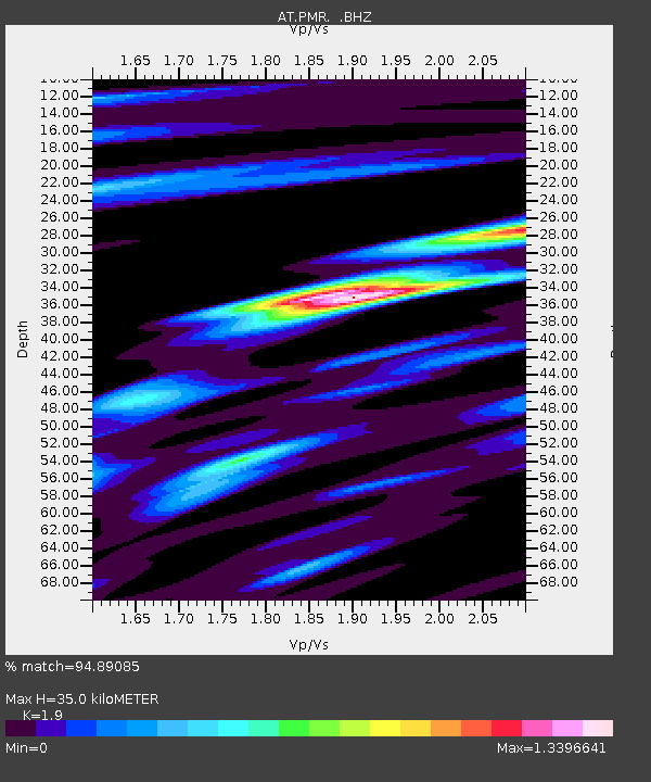
| Estimated Moho Depth: |
35.0 km |
| Estimated Crust Vp/Vs: |
1.90 |
| Assumed Crust Vp: |
6.566 km/s |
| Estimated Crust Vs: |
3.456 km/s |
| Estimated Crust Poisson's Ratio: |
0.31 |
|
| Radial Match: |
94.89085 % |
| Radial Bump: |
400 |
| Transverse Match: |
88.681595 % |
| Transverse Bump: |
400 |
| SOD ConfigId: |
626651 |
| Insert Time: |
2014-04-25 07:35:29.644 +0000 |
| GWidth: |
2.5 |
| Max Bumps: |
400 |
| Tol: |
0.001 |
|

Signal To Noise
| Channel | StoN | STA | LTA |
| AT:PMR: :BHZ:20140411T07:18:57.24001Z | 58.576775 | 6.621898E-6 | 1.13046475E-7 |
| AT:PMR: :BHN:20140411T07:18:57.24001Z | 9.336865 | 8.959306E-7 | 9.5956246E-8 |
| AT:PMR: :BHE:20140411T07:18:57.24001Z | 31.814117 | 2.813508E-6 | 8.843584E-8 |
| Arrivals |
| Ps | 4.9 SECOND |
| PpPs | 15 SECOND |
| PsPs/PpSs | 20 SECOND |


