You are here: Home > Network List > AZ - ANZA Regional Network Stations List
> Station MONP2 Monument Peak TA Vault, Mt. Laguna, CA, USA > Earthquake Result Viewer
MONP2 Monument Peak TA Vault, Mt. Laguna, CA, USA - Earthquake Result Viewer
| Earthquake location: |
Solomon Islands |
| Earthquake latitude/longitude: |
-6.6/155.1 |
| Earthquake time(UTC): |
2014/04/11 (101) 07:07:21 GMT |
| Earthquake Depth: |
50 km |
| Earthquake Magnitude: |
7.1 MWW, 7.0 MWB, 7.3 MI |
| Earthquake Catalog/Contributor: |
NEIC PDE/NEIC COMCAT |
|
| Network: |
AZ ANZA Regional Network |
| Station: |
MONP2 Monument Peak TA Vault, Mt. Laguna, CA, USA |
| Lat/Lon: |
32.89 N/116.42 W |
| Elevation: |
1000 m |
|
| Distance: |
92.3 deg |
| Az: |
57.326 deg |
| Baz: |
263.659 deg |
| Ray Param: |
0.04146142 |
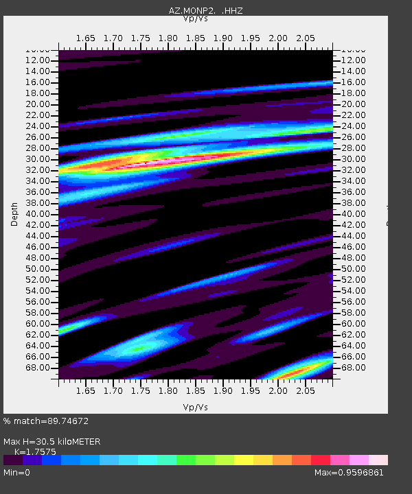
| Estimated Moho Depth: |
30.5 km |
| Estimated Crust Vp/Vs: |
1.76 |
| Assumed Crust Vp: |
6.264 km/s |
| Estimated Crust Vs: |
3.564 km/s |
| Estimated Crust Poisson's Ratio: |
0.26 |
|
| Radial Match: |
89.74672 % |
| Radial Bump: |
314 |
| Transverse Match: |
86.232056 % |
| Transverse Bump: |
346 |
| SOD ConfigId: |
626651 |
| Insert Time: |
2014-04-25 07:37:50.959 +0000 |
| GWidth: |
2.5 |
| Max Bumps: |
400 |
| Tol: |
0.001 |
|

Signal To Noise
| Channel | StoN | STA | LTA |
| AZ:MONP2: :HHZ:20140411T07:19:55.518025Z | 20.39441 | 3.023265E-6 | 1.4823988E-7 |
| AZ:MONP2: :HHN:20140411T07:19:55.518025Z | 0.885224 | 6.452697E-8 | 7.2893386E-8 |
| AZ:MONP2: :HHE:20140411T07:19:55.518025Z | 5.082615 | 1.0609026E-6 | 2.0873165E-7 |
| Arrivals |
| Ps | 3.8 SECOND |
| PpPs | 13 SECOND |
| PsPs/PpSs | 17 SECOND |


