You are here: Home > Network List > AZ - ANZA Regional Network Stations List
> Station SOL AZ.SOL > Earthquake Result Viewer
SOL AZ.SOL - Earthquake Result Viewer
| Earthquake location: |
Solomon Islands |
| Earthquake latitude/longitude: |
-6.6/155.1 |
| Earthquake time(UTC): |
2014/04/11 (101) 07:07:21 GMT |
| Earthquake Depth: |
50 km |
| Earthquake Magnitude: |
7.1 MWW, 7.0 MWB, 7.3 MI |
| Earthquake Catalog/Contributor: |
NEIC PDE/NEIC COMCAT |
|
| Network: |
AZ ANZA Regional Network |
| Station: |
SOL AZ.SOL |
| Lat/Lon: |
32.84 N/117.25 W |
| Elevation: |
245 m |
|
| Distance: |
91.6 deg |
| Az: |
57.297 deg |
| Baz: |
263.214 deg |
| Ray Param: |
0.0415669 |
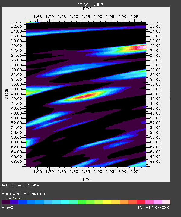
| Estimated Moho Depth: |
20.25 km |
| Estimated Crust Vp/Vs: |
2.10 |
| Assumed Crust Vp: |
6.264 km/s |
| Estimated Crust Vs: |
2.986 km/s |
| Estimated Crust Poisson's Ratio: |
0.35 |
|
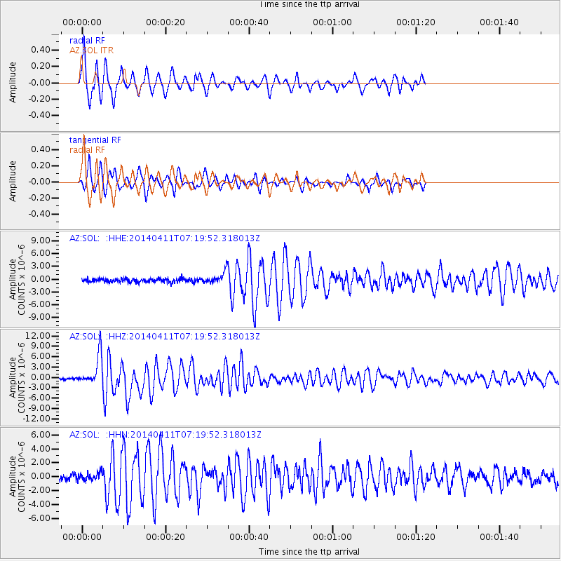
| Radial Match: |
92.69664 % |
| Radial Bump: |
291 |
| Transverse Match: |
86.34357 % |
| Transverse Bump: |
322 |
| SOD ConfigId: |
626651 |
| Insert Time: |
2014-04-25 07:38:08.174 +0000 |
| GWidth: |
2.5 |
| Max Bumps: |
400 |
| Tol: |
0.001 |
|
Signal To Noise
| Channel | StoN | STA | LTA |
| AZ:SOL: :HHZ:20140411T07:19:52.318013Z | 18.94023 | 4.509791E-6 | 2.3810647E-7 |
| AZ:SOL: :HHN:20140411T07:19:52.318013Z | 1.881574 | 5.677036E-7 | 3.017174E-7 |
| AZ:SOL: :HHE:20140411T07:19:52.318013Z | 3.4246168 | 1.4090449E-6 | 4.11446E-7 |
| Arrivals |
| Ps | 3.6 SECOND |
| PpPs | 9.9 SECOND |
| PsPs/PpSs | 13 SECOND |


