You are here: Home > Network List > TA - USArray Transportable Network (new EarthScope stations) Stations List
> Station I58A Old Forge, NY, USA > Earthquake Result Viewer
I58A Old Forge, NY, USA - Earthquake Result Viewer

| Earthquake location: |
Fox Islands, Aleutian Islands |
| Earthquake latitude/longitude: |
52.3/-168.6 |
| Earthquake time(UTC): |
2015/02/03 (034) 07:16:54 GMT |
| Earthquake Depth: |
16 km |
| Earthquake Magnitude: |
5.6 MB |
| Earthquake Catalog/Contributor: |
NEIC PDE/NEIC ALERT |
|
| Network: |
TA USArray Transportable Network (new EarthScope stations) |
| Station: |
I58A Old Forge, NY, USA |
| Lat/Lon: |
43.69 N/74.97 W |
| Elevation: |
599 m |
|
| Distance: |
59.0 deg |
| Az: |
57.626 deg |
| Baz: |
314.4 deg |
| Ray Param: |
0.06246473 |
| Estimated Moho Depth: |
24.75 km |
| Estimated Crust Vp/Vs: |
1.71 |
| Assumed Crust Vp: |
6.419 km/s |
| Estimated Crust Vs: |
3.765 km/s |
| Estimated Crust Poisson's Ratio: |
0.24 |
|
| Radial Match: |
80.38156 % |
| Radial Bump: |
400 |
| Transverse Match: |
40.115654 % |
| Transverse Bump: |
399 |
| SOD ConfigId: |
7019011 |
| Insert Time: |
2019-04-16 15:37:05.779 +0000 |
| GWidth: |
2.5 |
| Max Bumps: |
400 |
| Tol: |
0.001 |
|
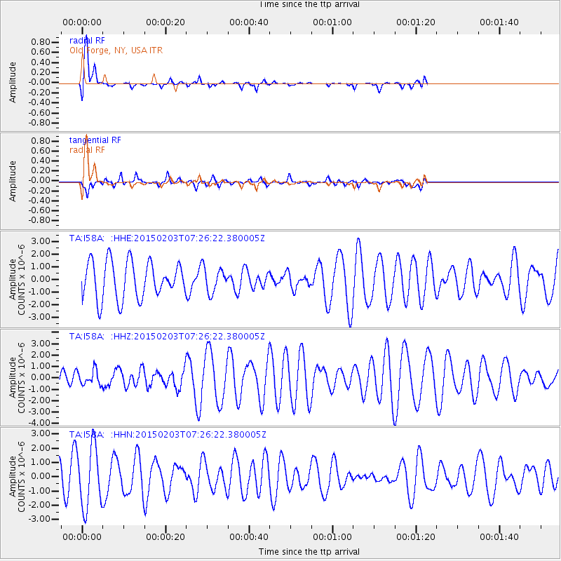
Signal To Noise
| Channel | StoN | STA | LTA |
| TA:I58A: :HHZ:20150203T07:26:22.380005Z | 0.44292662 | 6.359348E-7 | 1.4357565E-6 |
| TA:I58A: :HHN:20150203T07:26:22.380005Z | 2.6382463 | 2.1295684E-6 | 8.0719093E-7 |
| TA:I58A: :HHE:20150203T07:26:22.380005Z | 0.6738319 | 9.937471E-7 | 1.4747701E-6 |
| Arrivals |
| Ps | 2.9 SECOND |
| PpPs | 9.9 SECOND |
| PsPs/PpSs | 13 SECOND |


