You are here: Home > Network List > IC - New China Digital Seismograph Network Stations List
> Station WMQ Urumqi, Xinjiang Province, China > Earthquake Result Viewer
WMQ Urumqi, Xinjiang Province, China - Earthquake Result Viewer
| Earthquake location: |
Solomon Islands |
| Earthquake latitude/longitude: |
-6.6/155.1 |
| Earthquake time(UTC): |
2014/04/11 (101) 07:07:21 GMT |
| Earthquake Depth: |
50 km |
| Earthquake Magnitude: |
7.1 MWW, 7.0 MWB, 7.3 MI |
| Earthquake Catalog/Contributor: |
NEIC PDE/NEIC COMCAT |
|
| Network: |
IC New China Digital Seismograph Network |
| Station: |
WMQ Urumqi, Xinjiang Province, China |
| Lat/Lon: |
43.81 N/87.70 E |
| Elevation: |
850 m |
|
| Distance: |
78.6 deg |
| Az: |
317.032 deg |
| Baz: |
110.719 deg |
| Ray Param: |
0.04944606 |
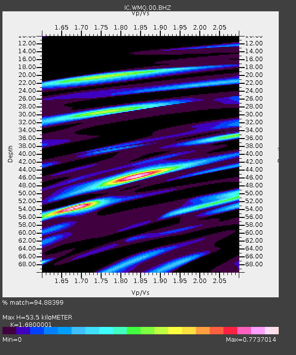
| Estimated Moho Depth: |
53.5 km |
| Estimated Crust Vp/Vs: |
1.68 |
| Assumed Crust Vp: |
6.242 km/s |
| Estimated Crust Vs: |
3.715 km/s |
| Estimated Crust Poisson's Ratio: |
0.23 |
|
| Radial Match: |
94.88399 % |
| Radial Bump: |
400 |
| Transverse Match: |
90.907425 % |
| Transverse Bump: |
400 |
| SOD ConfigId: |
626651 |
| Insert Time: |
2014-04-25 07:42:14.283 +0000 |
| GWidth: |
2.5 |
| Max Bumps: |
400 |
| Tol: |
0.001 |
|
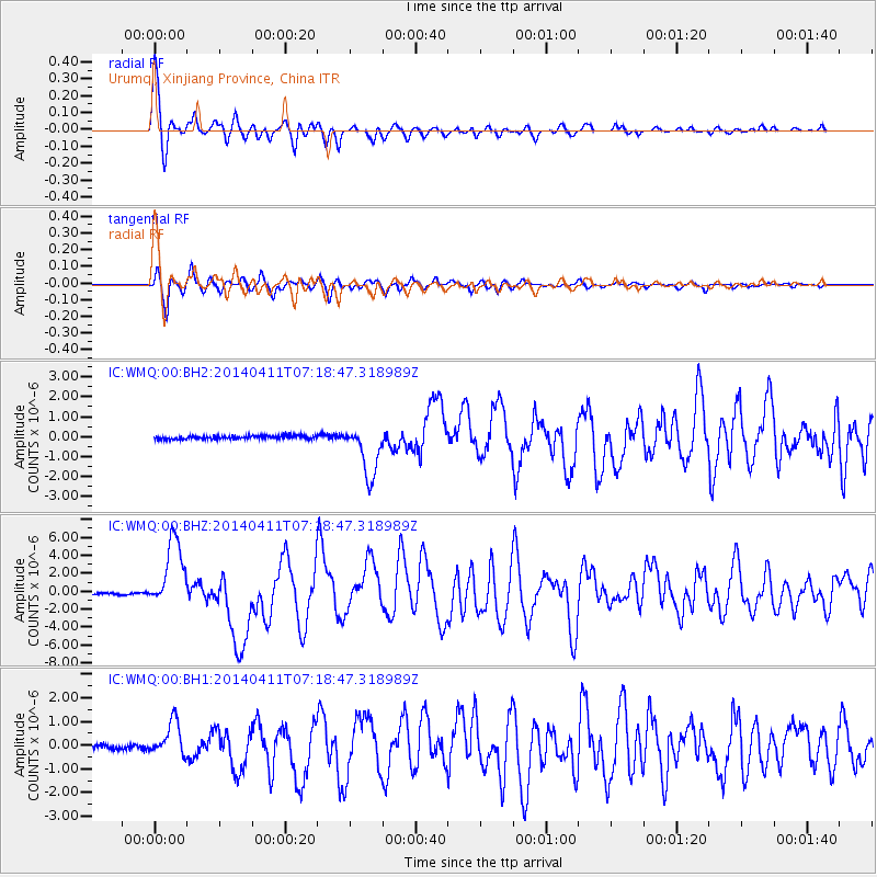
Signal To Noise
| Channel | StoN | STA | LTA |
| IC:WMQ:00:BHZ:20140411T07:18:47.318989Z | 30.339712 | 3.8275184E-6 | 1.261554E-7 |
| IC:WMQ:00:BH1:20140411T07:18:47.318989Z | 7.7412 | 7.1769693E-7 | 9.2711325E-8 |
| IC:WMQ:00:BH2:20140411T07:18:47.318989Z | 14.901314 | 1.2996592E-6 | 8.721776E-8 |
| Arrivals |
| Ps | 6.0 SECOND |
| PpPs | 22 SECOND |
| PsPs/PpSs | 28 SECOND |


