You are here: Home > Network List > IU - Global Seismograph Network (GSN - IRIS/USGS) Stations List
> Station AFI Afiamalu, Samoa > Earthquake Result Viewer
AFI Afiamalu, Samoa - Earthquake Result Viewer
| Earthquake location: |
Solomon Islands |
| Earthquake latitude/longitude: |
-6.6/155.1 |
| Earthquake time(UTC): |
2014/04/11 (101) 07:07:21 GMT |
| Earthquake Depth: |
50 km |
| Earthquake Magnitude: |
7.1 MWW, 7.0 MWB, 7.3 MI |
| Earthquake Catalog/Contributor: |
NEIC PDE/NEIC COMCAT |
|
| Network: |
IU Global Seismograph Network (GSN - IRIS/USGS) |
| Station: |
AFI Afiamalu, Samoa |
| Lat/Lon: |
13.91 S/171.78 W |
| Elevation: |
706 m |
|
| Distance: |
33.4 deg |
| Az: |
105.182 deg |
| Baz: |
279.134 deg |
| Ray Param: |
0.078120425 |
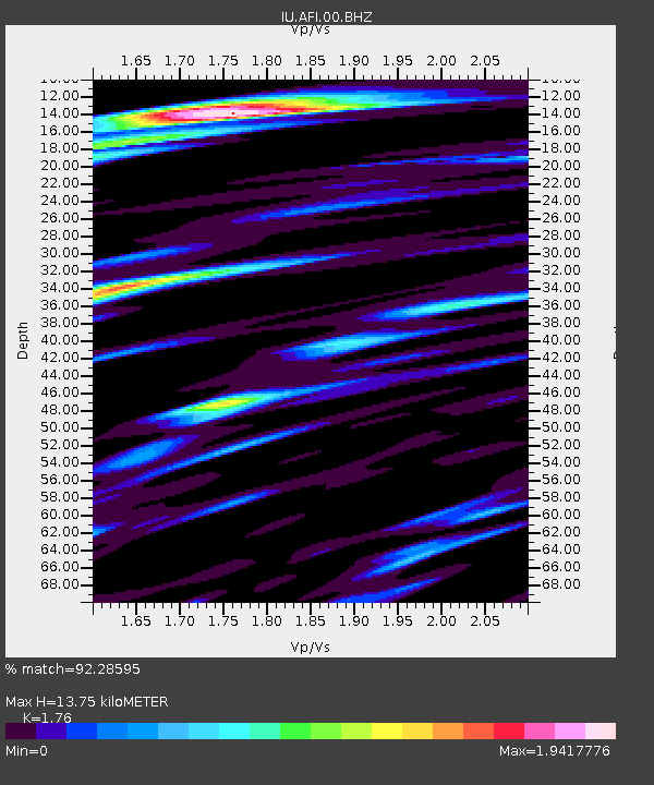
| Estimated Moho Depth: |
13.75 km |
| Estimated Crust Vp/Vs: |
1.76 |
| Assumed Crust Vp: |
4.24 km/s |
| Estimated Crust Vs: |
2.409 km/s |
| Estimated Crust Poisson's Ratio: |
0.26 |
|
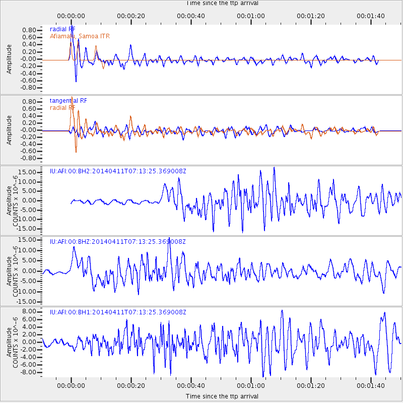
| Radial Match: |
92.28595 % |
| Radial Bump: |
400 |
| Transverse Match: |
79.2612 % |
| Transverse Bump: |
400 |
| SOD ConfigId: |
626651 |
| Insert Time: |
2014-04-25 07:42:54.905 +0000 |
| GWidth: |
2.5 |
| Max Bumps: |
400 |
| Tol: |
0.001 |
|
Signal To Noise
| Channel | StoN | STA | LTA |
| IU:AFI:00:BHZ:20140411T07:13:25.369008Z | 8.968937 | 5.8130163E-6 | 6.4812764E-7 |
| IU:AFI:00:BH1:20140411T07:13:25.369008Z | 1.1848792 | 1.1501338E-6 | 9.70676E-7 |
| IU:AFI:00:BH2:20140411T07:13:25.369008Z | 6.414853 | 5.1743305E-6 | 8.0661715E-7 |
| Arrivals |
| Ps | 2.5 SECOND |
| PpPs | 8.7 SECOND |
| PsPs/PpSs | 11 SECOND |


