You are here: Home > Network List > IU - Global Seismograph Network (GSN - IRIS/USGS) Stations List
> Station NWAO Narrogin, Australia > Earthquake Result Viewer
NWAO Narrogin, Australia - Earthquake Result Viewer
| Earthquake location: |
Solomon Islands |
| Earthquake latitude/longitude: |
-6.6/155.1 |
| Earthquake time(UTC): |
2014/04/11 (101) 07:07:21 GMT |
| Earthquake Depth: |
50 km |
| Earthquake Magnitude: |
7.1 MWW, 7.0 MWB, 7.3 MI |
| Earthquake Catalog/Contributor: |
NEIC PDE/NEIC COMCAT |
|
| Network: |
IU Global Seismograph Network (GSN - IRIS/USGS) |
| Station: |
NWAO Narrogin, Australia |
| Lat/Lon: |
32.93 S/117.24 E |
| Elevation: |
380 m |
|
| Distance: |
43.8 deg |
| Az: |
228.189 deg |
| Baz: |
61.692 deg |
| Ray Param: |
0.07218778 |
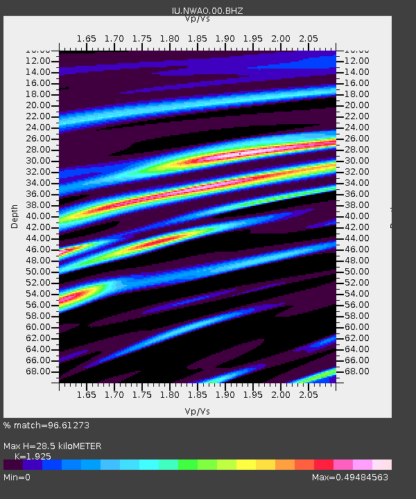
| Estimated Moho Depth: |
28.5 km |
| Estimated Crust Vp/Vs: |
1.92 |
| Assumed Crust Vp: |
6.419 km/s |
| Estimated Crust Vs: |
3.335 km/s |
| Estimated Crust Poisson's Ratio: |
0.32 |
|
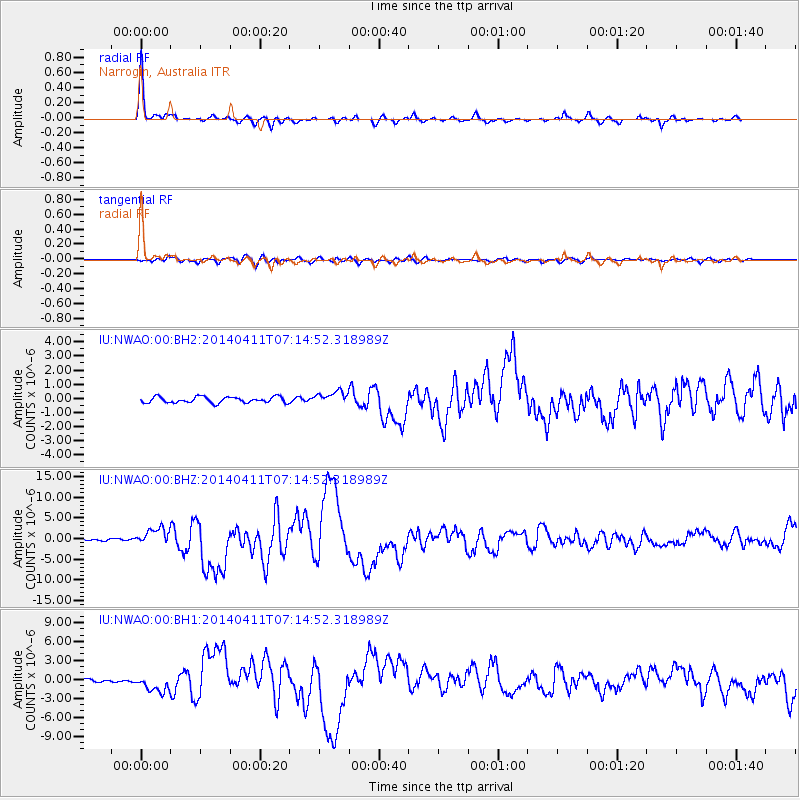
| Radial Match: |
96.61273 % |
| Radial Bump: |
259 |
| Transverse Match: |
82.08513 % |
| Transverse Bump: |
400 |
| SOD ConfigId: |
626651 |
| Insert Time: |
2014-04-25 07:43:16.125 +0000 |
| GWidth: |
2.5 |
| Max Bumps: |
400 |
| Tol: |
0.001 |
|
Signal To Noise
| Channel | StoN | STA | LTA |
| IU:NWAO:00:BHZ:20140411T07:14:52.318989Z | 11.038417 | 2.1543465E-6 | 1.9516807E-7 |
| IU:NWAO:00:BH1:20140411T07:14:52.318989Z | 6.9887753 | 1.425149E-6 | 2.039197E-7 |
| IU:NWAO:00:BH2:20140411T07:14:52.318989Z | 2.1355908 | 4.5011402E-7 | 2.1076791E-7 |
| Arrivals |
| Ps | 4.4 SECOND |
| PpPs | 12 SECOND |
| PsPs/PpSs | 17 SECOND |


