You are here: Home > Network List > IU - Global Seismograph Network (GSN - IRIS/USGS) Stations List
> Station POHA Pohakuloa, Hawaii, USA > Earthquake Result Viewer
POHA Pohakuloa, Hawaii, USA - Earthquake Result Viewer
| Earthquake location: |
Solomon Islands |
| Earthquake latitude/longitude: |
-6.6/155.1 |
| Earthquake time(UTC): |
2014/04/11 (101) 07:07:21 GMT |
| Earthquake Depth: |
50 km |
| Earthquake Magnitude: |
7.1 MWW, 7.0 MWB, 7.3 MI |
| Earthquake Catalog/Contributor: |
NEIC PDE/NEIC COMCAT |
|
| Network: |
IU Global Seismograph Network (GSN - IRIS/USGS) |
| Station: |
POHA Pohakuloa, Hawaii, USA |
| Lat/Lon: |
19.76 N/155.53 W |
| Elevation: |
1990 m |
|
| Distance: |
55.2 deg |
| Az: |
60.534 deg |
| Baz: |
246.68 deg |
| Ray Param: |
0.06481161 |
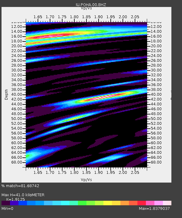
| Estimated Moho Depth: |
41.0 km |
| Estimated Crust Vp/Vs: |
1.91 |
| Assumed Crust Vp: |
5.195 km/s |
| Estimated Crust Vs: |
2.716 km/s |
| Estimated Crust Poisson's Ratio: |
0.31 |
|
| Radial Match: |
81.68742 % |
| Radial Bump: |
400 |
| Transverse Match: |
73.91958 % |
| Transverse Bump: |
400 |
| SOD ConfigId: |
626651 |
| Insert Time: |
2014-04-25 07:43:20.797 +0000 |
| GWidth: |
2.5 |
| Max Bumps: |
400 |
| Tol: |
0.001 |
|

Signal To Noise
| Channel | StoN | STA | LTA |
| IU:POHA:00:BHZ:20140411T07:16:19.269001Z | 7.83825 | 1.0621227E-5 | 1.3550508E-6 |
| IU:POHA:00:BH1:20140411T07:16:19.269001Z | 0.7862421 | 1.6869728E-6 | 2.1456149E-6 |
| IU:POHA:00:BH2:20140411T07:16:19.269001Z | 2.2846708 | 6.223934E-6 | 2.7242147E-6 |
| Arrivals |
| Ps | 7.4 SECOND |
| PpPs | 22 SECOND |
| PsPs/PpSs | 30 SECOND |


