You are here: Home > Network List > GL - Volcanologic Seismologic Observatory Network of Guadeloupe -OVSG Stations List
> Station MML Mamelle > Earthquake Result Viewer
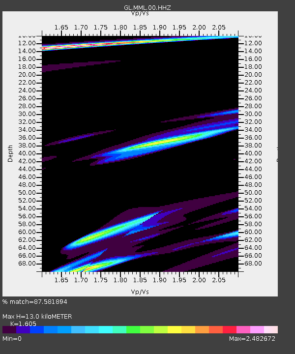
MML Mamelle - Earthquake Result Viewer
| Earthquake location: |
Fox Islands, Aleutian Islands |
| Earthquake latitude/longitude: |
52.3/-168.7 |
| Earthquake time(UTC): |
2015/02/03 (034) 07:27:25 GMT |
| Earthquake Depth: |
32 km |
| Earthquake Magnitude: |
5.4 MW |
| Earthquake Catalog/Contributor: |
ISC/ISC |
|
| Network: |
GL Volcanologic Seismologic Observatory Network of Guadeloupe -OVSG |
| Station: |
MML Mamelle |
| Lat/Lon: |
16.04 N/61.67 W |
| Elevation: |
1197 m |
|
| Distance: |
87.5 deg |
| Az: |
66.995 deg |
| Baz: |
323.998 deg |
| Ray Param: |
0.043268945 |
| Estimated Moho Depth: |
13.0 km |
| Estimated Crust Vp/Vs: |
1.61 |
| Assumed Crust Vp: |
6.048 km/s |
| Estimated Crust Vs: |
3.768 km/s |
| Estimated Crust Poisson's Ratio: |
0.18 |
|
| Radial Match: |
87.581894 % |
| Radial Bump: |
182 |
| Transverse Match: |
82.23446 % |
| Transverse Bump: |
273 |
| SOD ConfigId: |
7019011 |
| Insert Time: |
2019-04-16 15:43:57.954 +0000 |
| GWidth: |
2.5 |
| Max Bumps: |
400 |
| Tol: |
0.001 |
|

Signal To Noise
| Channel | StoN | STA | LTA |
| GL:MML:00:HHZ:20150203T07:39:38.349978Z | 0.68612945 | 3.1504776E-6 | 4.5916663E-6 |
| GL:MML:00:HHN:20150203T07:39:38.349978Z | 0.81983787 | 3.6616289E-6 | 4.4662843E-6 |
| GL:MML:00:HHE:20150203T07:39:38.349978Z | 2.074291 | 8.7566754E-5 | 4.221527E-5 |
| Arrivals |
| Ps | 1.3 SECOND |
| PpPs | 5.5 SECOND |
| PsPs/PpSs | 6.8 SECOND |


