You are here: Home > Network List > UU - University of Utah Regional Network Stations List
> Station LCMT Little Creek Mountain, UT, USA > Earthquake Result Viewer
LCMT Little Creek Mountain, UT, USA - Earthquake Result Viewer
| Earthquake location: |
Solomon Islands |
| Earthquake latitude/longitude: |
-6.6/155.1 |
| Earthquake time(UTC): |
2014/04/11 (101) 07:07:21 GMT |
| Earthquake Depth: |
50 km |
| Earthquake Magnitude: |
7.1 MWW, 7.0 MWB, 7.3 MI |
| Earthquake Catalog/Contributor: |
NEIC PDE/NEIC COMCAT |
|
| Network: |
UU University of Utah Regional Network |
| Station: |
LCMT Little Creek Mountain, UT, USA |
| Lat/Lon: |
37.01 N/113.24 W |
| Elevation: |
1411 m |
|
| Distance: |
95.3 deg |
| Az: |
53.468 deg |
| Baz: |
265.729 deg |
| Ray Param: |
0.04079354 |
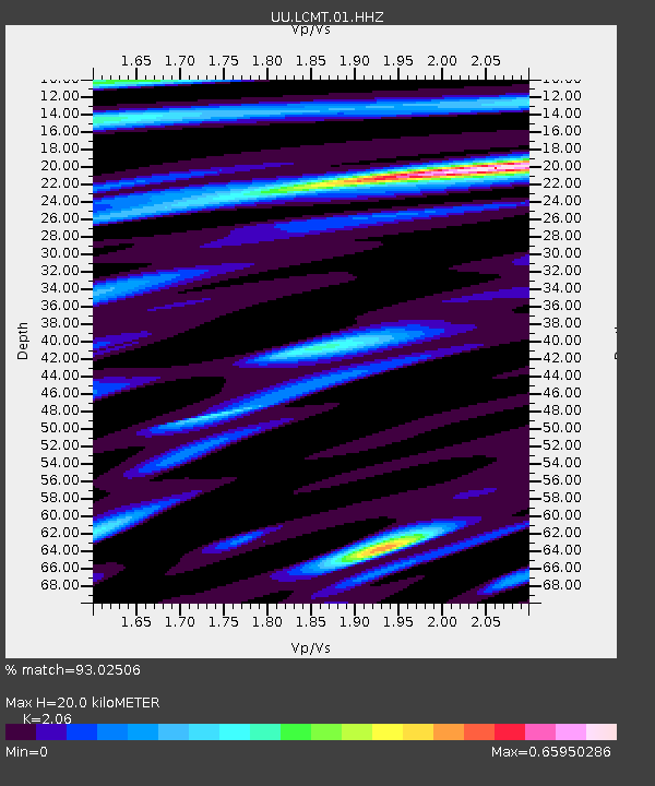
| Estimated Moho Depth: |
20.0 km |
| Estimated Crust Vp/Vs: |
2.06 |
| Assumed Crust Vp: |
6.194 km/s |
| Estimated Crust Vs: |
3.007 km/s |
| Estimated Crust Poisson's Ratio: |
0.35 |
|
| Radial Match: |
93.02506 % |
| Radial Bump: |
363 |
| Transverse Match: |
92.02615 % |
| Transverse Bump: |
363 |
| SOD ConfigId: |
626651 |
| Insert Time: |
2014-04-25 07:50:58.456 +0000 |
| GWidth: |
2.5 |
| Max Bumps: |
400 |
| Tol: |
0.001 |
|
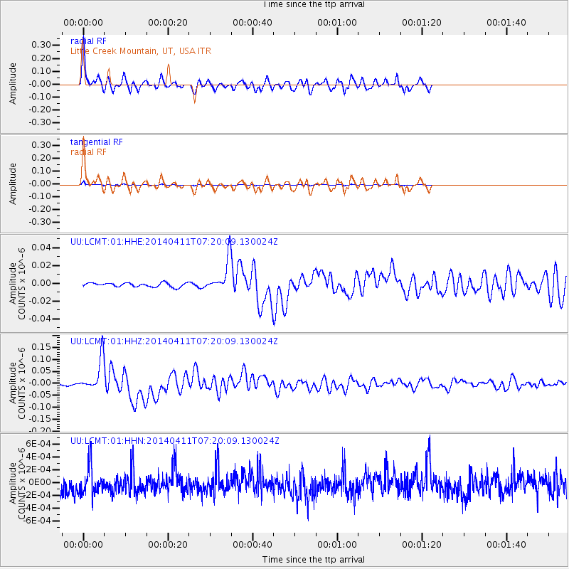
Signal To Noise
| Channel | StoN | STA | LTA |
| UU:LCMT:01:HHZ:20140411T07:20:09.130024Z | 22.45571 | 6.905599E-8 | 3.0752088E-9 |
| UU:LCMT:01:HHN:20140411T07:20:09.130024Z | 1.2994946 | 2.2062883E-10 | 1.6978048E-10 |
| UU:LCMT:01:HHE:20140411T07:20:09.130024Z | 8.100747 | 1.8095202E-8 | 2.2337694E-9 |
| Arrivals |
| Ps | 3.5 SECOND |
| PpPs | 9.7 SECOND |
| PsPs/PpSs | 13 SECOND |


