You are here: Home > Network List > UU - University of Utah Regional Network Stations List
> Station NOQ North Oquirrh Mountains, UT, USA > Earthquake Result Viewer
NOQ North Oquirrh Mountains, UT, USA - Earthquake Result Viewer
| Earthquake location: |
Solomon Islands |
| Earthquake latitude/longitude: |
-6.6/155.1 |
| Earthquake time(UTC): |
2014/04/11 (101) 07:07:21 GMT |
| Earthquake Depth: |
50 km |
| Earthquake Magnitude: |
7.1 MWW, 7.0 MWB, 7.3 MI |
| Earthquake Catalog/Contributor: |
NEIC PDE/NEIC COMCAT |
|
| Network: |
UU University of Utah Regional Network |
| Station: |
NOQ North Oquirrh Mountains, UT, USA |
| Lat/Lon: |
40.65 N/112.12 W |
| Elevation: |
1622 m |
|
| Distance: |
96.4 deg |
| Az: |
49.879 deg |
| Baz: |
266.797 deg |
| Ray Param: |
0.040494703 |
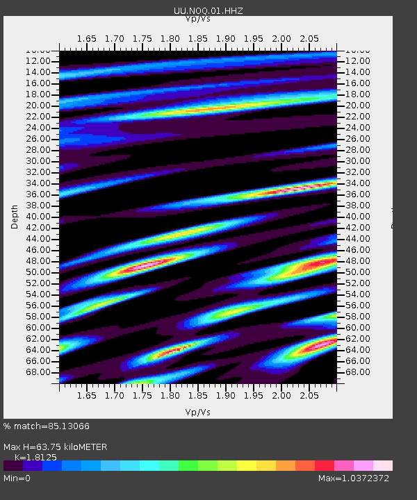
| Estimated Moho Depth: |
63.75 km |
| Estimated Crust Vp/Vs: |
1.81 |
| Assumed Crust Vp: |
6.276 km/s |
| Estimated Crust Vs: |
3.463 km/s |
| Estimated Crust Poisson's Ratio: |
0.28 |
|
| Radial Match: |
85.13066 % |
| Radial Bump: |
400 |
| Transverse Match: |
72.24937 % |
| Transverse Bump: |
400 |
| SOD ConfigId: |
626651 |
| Insert Time: |
2014-04-25 07:51:06.943 +0000 |
| GWidth: |
2.5 |
| Max Bumps: |
400 |
| Tol: |
0.001 |
|

Signal To Noise
| Channel | StoN | STA | LTA |
| UU:NOQ:01:HHZ:20140411T07:20:14.154011Z | 20.464304 | 4.8700283E-8 | 2.3797673E-9 |
| UU:NOQ:01:HHN:20140411T07:20:14.154011Z | 0.58288914 | 3.2046577E-9 | 5.4978853E-9 |
| UU:NOQ:01:HHE:20140411T07:20:14.154011Z | 1.9229828 | 1.20239685E-8 | 6.25277E-9 |
| Arrivals |
| Ps | 8.4 SECOND |
| PpPs | 28 SECOND |
| PsPs/PpSs | 36 SECOND |


