You are here: Home > Network List > TA - USArray Transportable Network (new EarthScope stations) Stations List
> Station G57A Newington, ON, CAN > Earthquake Result Viewer
G57A Newington, ON, CAN - Earthquake Result Viewer
| Earthquake location: |
Fox Islands, Aleutian Islands |
| Earthquake latitude/longitude: |
52.3/-168.7 |
| Earthquake time(UTC): |
2015/02/03 (034) 07:27:25 GMT |
| Earthquake Depth: |
32 km |
| Earthquake Magnitude: |
5.4 MW |
| Earthquake Catalog/Contributor: |
ISC/ISC |
|
| Network: |
TA USArray Transportable Network (new EarthScope stations) |
| Station: |
G57A Newington, ON, CAN |
| Lat/Lon: |
45.10 N/74.99 W |
| Elevation: |
96 m |
|
| Distance: |
58.0 deg |
| Az: |
56.412 deg |
| Baz: |
313.757 deg |
| Ray Param: |
0.06305055 |
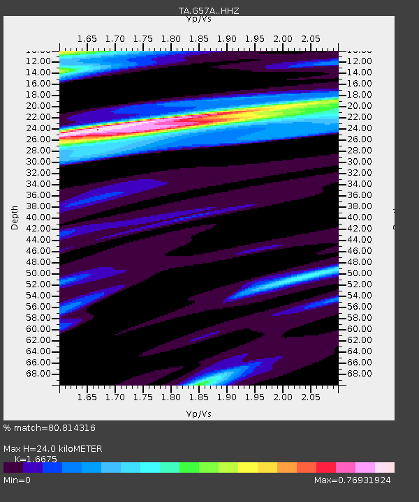
| Estimated Moho Depth: |
24.0 km |
| Estimated Crust Vp/Vs: |
1.67 |
| Assumed Crust Vp: |
6.419 km/s |
| Estimated Crust Vs: |
3.85 km/s |
| Estimated Crust Poisson's Ratio: |
0.22 |
|
| Radial Match: |
80.814316 % |
| Radial Bump: |
400 |
| Transverse Match: |
45.463047 % |
| Transverse Bump: |
394 |
| SOD ConfigId: |
7019011 |
| Insert Time: |
2019-04-16 15:48:02.068 +0000 |
| GWidth: |
2.5 |
| Max Bumps: |
400 |
| Tol: |
0.001 |
|
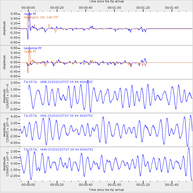
Signal To Noise
| Channel | StoN | STA | LTA |
| TA:G57A: :HHZ:20150203T07:36:44.409976Z | 1.4050529 | 1.7573082E-6 | 1.2507061E-6 |
| TA:G57A: :HHN:20150203T07:36:44.409976Z | 2.1351967 | 1.6919569E-6 | 7.924126E-7 |
| TA:G57A: :HHE:20150203T07:36:44.409976Z | 1.1588358 | 1.0591503E-6 | 9.13978E-7 |
| Arrivals |
| Ps | 2.6 SECOND |
| PpPs | 9.5 SECOND |
| PsPs/PpSs | 12 SECOND |


