You are here: Home > Network List > TA - USArray Transportable Network (new EarthScope stations) Stations List
> Station G59A Clarenceville, QC, USA > Earthquake Result Viewer
G59A Clarenceville, QC, USA - Earthquake Result Viewer
| Earthquake location: |
Fox Islands, Aleutian Islands |
| Earthquake latitude/longitude: |
52.3/-168.7 |
| Earthquake time(UTC): |
2015/02/03 (034) 07:27:25 GMT |
| Earthquake Depth: |
32 km |
| Earthquake Magnitude: |
5.4 MW |
| Earthquake Catalog/Contributor: |
ISC/ISC |
|
| Network: |
TA USArray Transportable Network (new EarthScope stations) |
| Station: |
G59A Clarenceville, QC, USA |
| Lat/Lon: |
45.08 N/73.18 W |
| Elevation: |
36 m |
|
| Distance: |
59.0 deg |
| Az: |
55.388 deg |
| Baz: |
314.496 deg |
| Ray Param: |
0.062442288 |
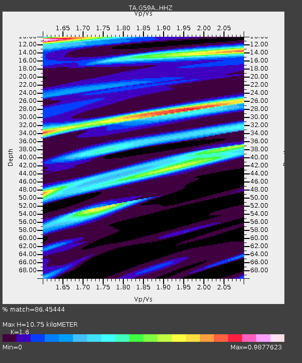
| Estimated Moho Depth: |
10.75 km |
| Estimated Crust Vp/Vs: |
1.60 |
| Assumed Crust Vp: |
6.419 km/s |
| Estimated Crust Vs: |
4.012 km/s |
| Estimated Crust Poisson's Ratio: |
0.18 |
|
| Radial Match: |
86.45444 % |
| Radial Bump: |
400 |
| Transverse Match: |
40.008392 % |
| Transverse Bump: |
400 |
| SOD ConfigId: |
7019011 |
| Insert Time: |
2019-04-16 15:48:03.469 +0000 |
| GWidth: |
2.5 |
| Max Bumps: |
400 |
| Tol: |
0.001 |
|
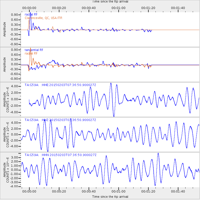
Signal To Noise
| Channel | StoN | STA | LTA |
| TA:G59A: :HHZ:20150203T07:36:50.900027Z | 0.72056127 | 1.1626779E-6 | 1.6135726E-6 |
| TA:G59A: :HHN:20150203T07:36:50.900027Z | 0.78577036 | 9.99322E-7 | 1.2717735E-6 |
| TA:G59A: :HHE:20150203T07:36:50.900027Z | 1.1786594 | 1.2939755E-6 | 1.0978366E-6 |
| Arrivals |
| Ps | 1.1 SECOND |
| PpPs | 4.1 SECOND |
| PsPs/PpSs | 5.2 SECOND |


