You are here: Home > Network List > IU - Global Seismograph Network (GSN - IRIS/USGS) Stations List
> Station GNI Garni, Armenia > Earthquake Result Viewer
GNI Garni, Armenia - Earthquake Result Viewer

| Earthquake location: |
Southern Sumatra, Indonesia |
| Earthquake latitude/longitude: |
-0.7/99.9 |
| Earthquake time(UTC): |
2009/09/30 (273) 10:16:09 GMT |
| Earthquake Depth: |
81 km |
| Earthquake Magnitude: |
7.1 MB, 7.5 MW, 7.5 MW |
| Earthquake Catalog/Contributor: |
WHDF/NEIC |
|
| Network: |
IU Global Seismograph Network (GSN - IRIS/USGS) |
| Station: |
GNI Garni, Armenia |
| Lat/Lon: |
40.15 N/44.74 E |
| Elevation: |
1609 m |
|
| Distance: |
64.5 deg |
| Az: |
315.844 deg |
| Baz: |
114.667 deg |
| Ray Param: |
0.058668826 |
| Estimated Moho Depth: |
35.75 km |
| Estimated Crust Vp/Vs: |
1.90 |
| Assumed Crust Vp: |
6.291 km/s |
| Estimated Crust Vs: |
3.315 km/s |
| Estimated Crust Poisson's Ratio: |
0.31 |
|
| Radial Match: |
87.21898 % |
| Radial Bump: |
400 |
| Transverse Match: |
89.80703 % |
| Transverse Bump: |
400 |
| SOD ConfigId: |
1 |
| Insert Time: |
2010-02-19 00:25:04.299 +0000 |
| GWidth: |
2.5 |
| Max Bumps: |
400 |
| Tol: |
0.001 |
|
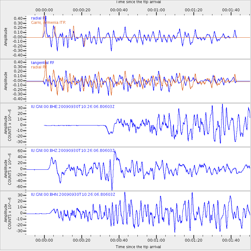
Signal To Noise
| Channel | StoN | STA | LTA |
| IU:GNI:00:BHZ:20090930T10:26:06.80603Z | 60.37488 | 1.729594E-5 | 2.8647577E-7 |
| IU:GNI:00:BHN:20090930T10:26:06.80603Z | 19.739113 | 2.478205E-6 | 1.2554794E-7 |
| IU:GNI:00:BHE:20090930T10:26:06.80603Z | 36.735798 | 5.5626906E-6 | 1.5142426E-7 |
| Arrivals |
| Ps | 5.3 SECOND |
| PpPs | 16 SECOND |
| PsPs/PpSs | 21 SECOND |


