You are here: Home > Network List > II - Global Seismograph Network (GSN - IRIS/IDA) Stations List
> Station BFO Black Forest Observatory, Schiltach, Germany > Earthquake Result Viewer
BFO Black Forest Observatory, Schiltach, Germany - Earthquake Result Viewer
| Earthquake location: |
Central Mid-Atlantic Ridge |
| Earthquake latitude/longitude: |
8.0/-39.2 |
| Earthquake time(UTC): |
2007/08/20 (232) 22:42:29 GMT |
| Earthquake Depth: |
10 km |
| Earthquake Magnitude: |
6.3 MB, 6.4 MS, 6.5 MW |
| Earthquake Catalog/Contributor: |
WHDF/NEIC |
|
| Network: |
II Global Seismograph Network (GSN - IRIS/IDA) |
| Station: |
BFO Black Forest Observatory, Schiltach, Germany |
| Lat/Lon: |
48.33 N/8.33 E |
| Elevation: |
589 m |
|
| Distance: |
56.7 deg |
| Az: |
36.12 deg |
| Baz: |
241.023 deg |
| Ray Param: |
0.063980326 |
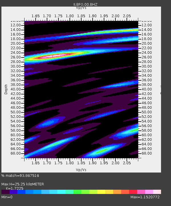
| Estimated Moho Depth: |
25.25 km |
| Estimated Crust Vp/Vs: |
1.72 |
| Assumed Crust Vp: |
6.264 km/s |
| Estimated Crust Vs: |
3.636 km/s |
| Estimated Crust Poisson's Ratio: |
0.25 |
|
| Radial Match: |
93.867516 % |
| Radial Bump: |
345 |
| Transverse Match: |
80.130516 % |
| Transverse Bump: |
400 |
| SOD ConfigId: |
2564 |
| Insert Time: |
2010-03-01 20:36:23.489 +0000 |
| GWidth: |
2.5 |
| Max Bumps: |
400 |
| Tol: |
0.001 |
|

Signal To Noise
| Channel | StoN | STA | LTA |
| II:BFO:00:BHN:20070820T22:51:41.614021Z | 3.32159 | 6.218506E-7 | 1.8721474E-7 |
| II:BFO:00:BHE:20070820T22:51:41.614021Z | 8.291376 | 1.1460787E-6 | 1.382254E-7 |
| II:BFO:00:BHZ:20070820T22:51:41.614021Z | 20.205812 | 2.6745784E-6 | 1.3236678E-7 |
| Arrivals |
| Ps | 3.1 SECOND |
| PpPs | 10 SECOND |
| PsPs/PpSs | 14 SECOND |


