You are here: Home > Network List > UW - Pacific Northwest Regional Seismic Network Stations List
> Station MRBL Marblemount, WA, USA > Earthquake Result Viewer
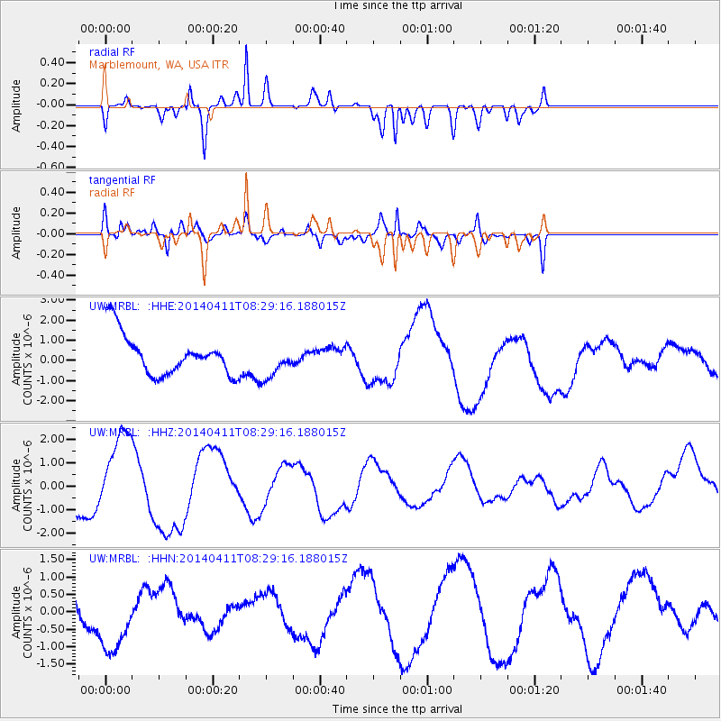
MRBL Marblemount, WA, USA - Earthquake Result Viewer
*The percent match for this event was below the threshold and hence no stack was calculated.
| Earthquake location: |
Solomon Islands |
| Earthquake latitude/longitude: |
-6.9/155.0 |
| Earthquake time(UTC): |
2014/04/11 (101) 08:16:48 GMT |
| Earthquake Depth: |
39 km |
| Earthquake Magnitude: |
6.5 MWW, 6.8 MI |
| Earthquake Catalog/Contributor: |
NEIC PDE/NEIC COMCAT |
|
| Network: |
UW Pacific Northwest Regional Seismic Network |
| Station: |
MRBL Marblemount, WA, USA |
| Lat/Lon: |
48.52 N/121.48 W |
| Elevation: |
75 m |
|
| Distance: |
90.8 deg |
| Az: |
41.35 deg |
| Baz: |
260.629 deg |
| Ray Param: |
$rayparam |
*The percent match for this event was below the threshold and hence was not used in the summary stack. |
|
| Radial Match: |
84.456985 % |
| Radial Bump: |
397 |
| Transverse Match: |
85.44364 % |
| Transverse Bump: |
394 |
| SOD ConfigId: |
626651 |
| Insert Time: |
2014-04-25 08:38:19.129 +0000 |
| GWidth: |
2.5 |
| Max Bumps: |
400 |
| Tol: |
0.001 |
|
Signal To Noise
| Channel | StoN | STA | LTA |
| UW:MRBL: :HHZ:20140411T08:29:16.188015Z | 3.3303185 | 1.8222802E-6 | 5.4717896E-7 |
| UW:MRBL: :HHN:20140411T08:29:16.188015Z | 2.4903605 | 1.0446383E-6 | 4.1947274E-7 |
| UW:MRBL: :HHE:20140411T08:29:16.188015Z | 0.8632266 | 8.74719E-7 | 1.0133133E-6 |
| Arrivals |
| Ps | |
| PpPs | |
| PsPs/PpSs | |


