You are here: Home > Network List > TA - USArray Transportable Network (new EarthScope stations) Stations List
> Station G59A Clarenceville, QC, USA > Earthquake Result Viewer
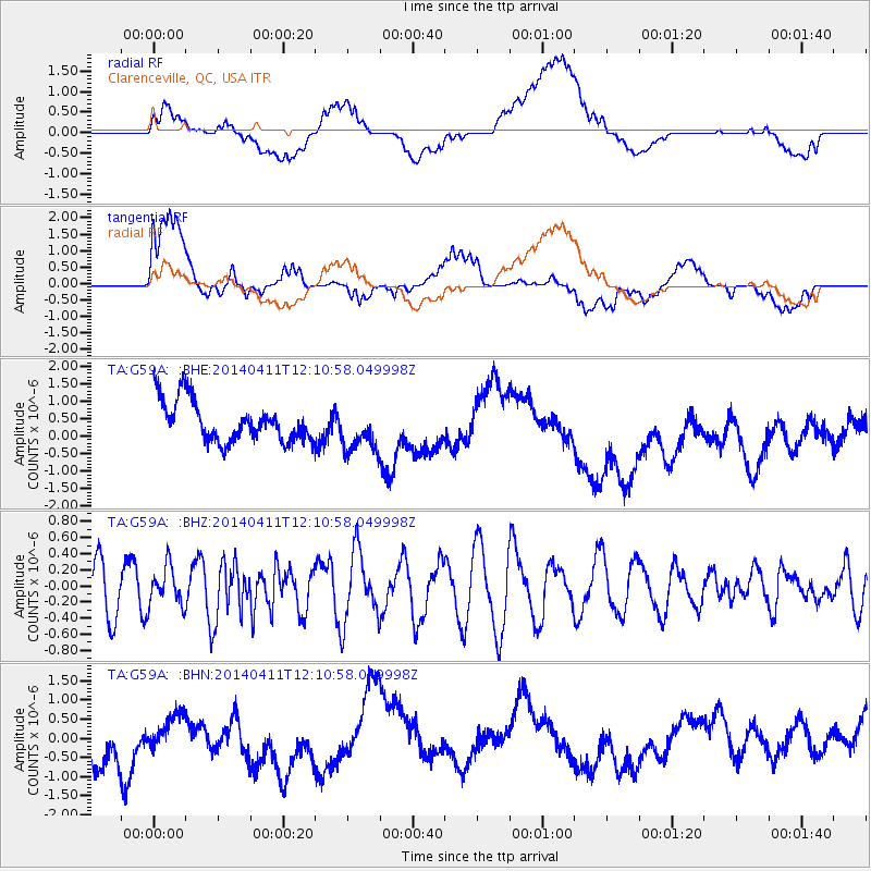
G59A Clarenceville, QC, USA - Earthquake Result Viewer
*The percent match for this event was below the threshold and hence no stack was calculated.
| Earthquake location: |
Near Coast Of Northern Chile |
| Earthquake latitude/longitude: |
-20.1/-70.5 |
| Earthquake time(UTC): |
2014/04/11 (101) 12:00:51 GMT |
| Earthquake Depth: |
22 km |
| Earthquake Magnitude: |
5.5 MB |
| Earthquake Catalog/Contributor: |
NEIC PDE/NEIC COMCAT |
|
| Network: |
TA USArray Transportable Network (new EarthScope stations) |
| Station: |
G59A Clarenceville, QC, USA |
| Lat/Lon: |
45.08 N/73.18 W |
| Elevation: |
36 m |
|
| Distance: |
64.9 deg |
| Az: |
357.937 deg |
| Baz: |
177.263 deg |
| Ray Param: |
$rayparam |
*The percent match for this event was below the threshold and hence was not used in the summary stack. |
|
| Radial Match: |
58.672615 % |
| Radial Bump: |
400 |
| Transverse Match: |
36.20881 % |
| Transverse Bump: |
400 |
| SOD ConfigId: |
626651 |
| Insert Time: |
2014-04-25 12:29:44.911 +0000 |
| GWidth: |
2.5 |
| Max Bumps: |
400 |
| Tol: |
0.001 |
|
Signal To Noise
| Channel | StoN | STA | LTA |
| TA:G59A: :BHZ:20140411T12:10:58.049998Z | 0.8314362 | 2.4040307E-7 | 2.8914192E-7 |
| TA:G59A: :BHN:20140411T12:10:58.049998Z | 0.42675072 | 4.883787E-7 | 1.1444121E-6 |
| TA:G59A: :BHE:20140411T12:10:58.049998Z | 1.1487917 | 6.6551013E-7 | 5.7931317E-7 |
| Arrivals |
| Ps | |
| PpPs | |
| PsPs/PpSs | |


