You are here: Home > Network List > II - Global Seismograph Network (GSN - IRIS/IDA) Stations List
> Station BFO Black Forest Observatory, Schiltach, Germany > Earthquake Result Viewer
BFO Black Forest Observatory, Schiltach, Germany - Earthquake Result Viewer

| Earthquake location: |
East Of Kuril Islands |
| Earthquake latitude/longitude: |
46.2/154.5 |
| Earthquake time(UTC): |
2007/01/13 (013) 04:23:21 GMT |
| Earthquake Depth: |
10 km |
| Earthquake Magnitude: |
7.3 MB, 8.2 MS, 8.1 MW, 7.9 MW |
| Earthquake Catalog/Contributor: |
WHDF/NEIC |
|
| Network: |
II Global Seismograph Network (GSN - IRIS/IDA) |
| Station: |
BFO Black Forest Observatory, Schiltach, Germany |
| Lat/Lon: |
48.33 N/8.33 E |
| Elevation: |
589 m |
|
| Distance: |
81.3 deg |
| Az: |
337.938 deg |
| Baz: |
22.995 deg |
| Ray Param: |
0.04768911 |
| Estimated Moho Depth: |
25.75 km |
| Estimated Crust Vp/Vs: |
1.74 |
| Assumed Crust Vp: |
6.264 km/s |
| Estimated Crust Vs: |
3.61 km/s |
| Estimated Crust Poisson's Ratio: |
0.25 |
|
| Radial Match: |
97.47985 % |
| Radial Bump: |
400 |
| Transverse Match: |
88.5725 % |
| Transverse Bump: |
400 |
| SOD ConfigId: |
2564 |
| Insert Time: |
2010-03-01 20:37:09.452 +0000 |
| GWidth: |
2.5 |
| Max Bumps: |
400 |
| Tol: |
0.001 |
|
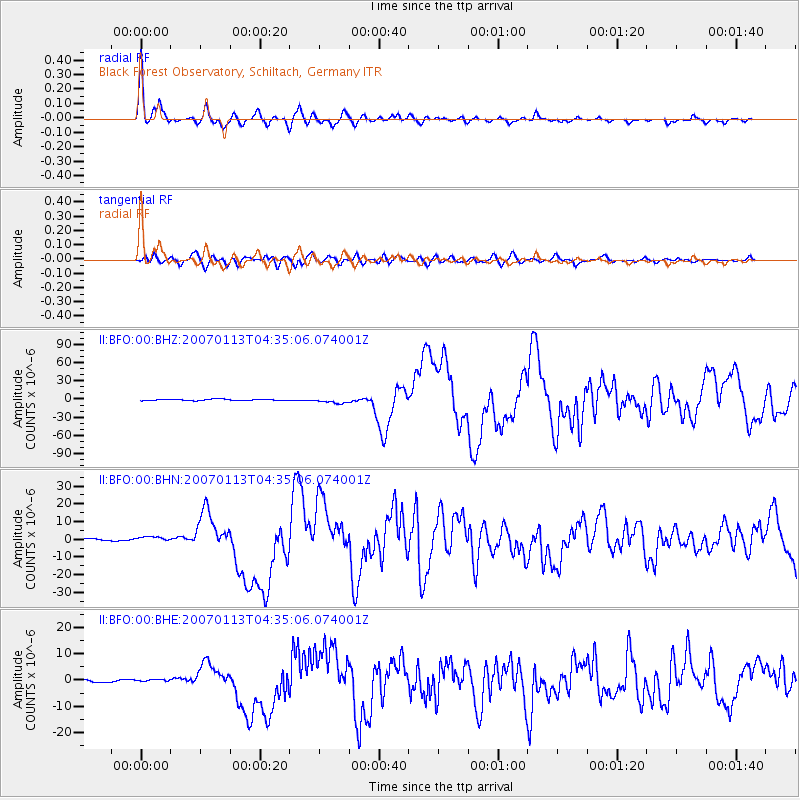
Signal To Noise
| Channel | StoN | STA | LTA |
| II:BFO:00:BHN:20070113T04:35:06.074001Z | 1.6403891 | 1.6160076E-6 | 9.851367E-7 |
| II:BFO:00:BHE:20070113T04:35:06.074001Z | 0.9209462 | 5.394596E-7 | 5.857667E-7 |
| II:BFO:00:BHZ:20070113T04:35:06.074001Z | 3.6510184 | 4.242444E-6 | 1.1619892E-6 |
| Arrivals |
| Ps | 3.1 SECOND |
| PpPs | 11 SECOND |
| PsPs/PpSs | 14 SECOND |


