You are here: Home > Network List > WY - Yellowstone Wyoming Seismic Network Stations List
> Station YHH Holmes Hill, YNP, WY, USA > Earthquake Result Viewer
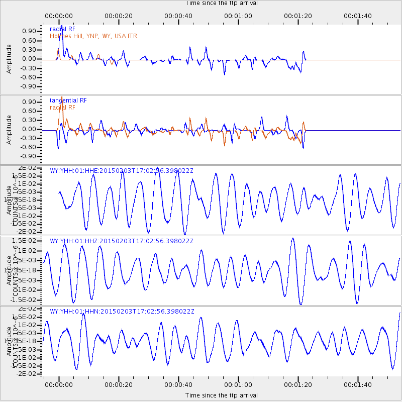
YHH Holmes Hill, YNP, WY, USA - Earthquake Result Viewer
*The percent match for this event was below the threshold and hence no stack was calculated.
| Earthquake location: |
South Of Fiji Islands |
| Earthquake latitude/longitude: |
-25.7/-176.1 |
| Earthquake time(UTC): |
2015/02/03 (034) 16:50:19 GMT |
| Earthquake Depth: |
10 km |
| Earthquake Magnitude: |
5.0 MW |
| Earthquake Catalog/Contributor: |
ISC/ISC |
|
| Network: |
WY Yellowstone Wyoming Seismic Network |
| Station: |
YHH Holmes Hill, YNP, WY, USA |
| Lat/Lon: |
44.79 N/110.85 W |
| Elevation: |
2717 m |
|
| Distance: |
91.9 deg |
| Az: |
40.305 deg |
| Baz: |
235.052 deg |
| Ray Param: |
$rayparam |
*The percent match for this event was below the threshold and hence was not used in the summary stack. |
|
| Radial Match: |
70.21104 % |
| Radial Bump: |
400 |
| Transverse Match: |
52.7204 % |
| Transverse Bump: |
400 |
| SOD ConfigId: |
7019011 |
| Insert Time: |
2019-04-16 15:57:09.695 +0000 |
| GWidth: |
2.5 |
| Max Bumps: |
400 |
| Tol: |
0.001 |
|
Signal To Noise
| Channel | StoN | STA | LTA |
| WY:YHH:01:HHZ:20150203T17:02:56.398022Z | 1.4812722 | 9.832482E-9 | 6.637863E-9 |
| WY:YHH:01:HHN:20150203T17:02:56.398022Z | 0.8689284 | 6.2032117E-9 | 7.1389223E-9 |
| WY:YHH:01:HHE:20150203T17:02:56.398022Z | 1.5492619 | 1.4598192E-8 | 9.422675E-9 |
| Arrivals |
| Ps | |
| PpPs | |
| PsPs/PpSs | |


